Wayne County, Indiana
Wayne County | |
|---|---|
U.S. county | |
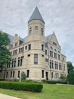 Wayne County Courthouse in Richmond | |
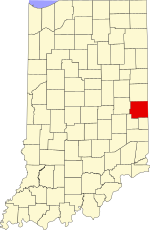 Location within the U.S. state of Indiana | |
 Indiana's location within the U.S. | |
| Coordinates: 39°52′N 85°01′W / 39.86°N 85.01°W | |
| Country | |
| State | |
| Founded | 1811 |
| Named for | Anthony Wayne |
| Seat | Richmond |
| Largest city | Richmond |
| Area | |
| • Total | 404.34 sq mi (1,047.2 km2) |
| • Land | 401.74 sq mi (1,040.5 km2) |
| • Water | 2.60 sq mi (6.7 km2) 0.64%% |
| Population | |
| • Estimate (2018) | 65,936 |
| • Density | 176/sq mi (68/km2) |
| Time zone | UTC−5 (Eastern) |
| • Summer (DST) | UTC−4 (EDT) |
| Congressional district | 6th |
| Website | co |
| Indiana county number 89 | |

Wayne County is a county located in east central Indiana, United States, on the border with Ohio. As of the 2010 census, the population was 68,917.[1] The county seat is Richmond.[2]
Wayne County comprises the Richmond, IN Micropolitan Statistical Area.
Richmond hosts Earlham College, a small private liberal arts college.
History[]
The first permanent European-American settlers in the area were Quakers from North Carolina. They settled about 1806 near the east fork of the Whitewater River, an area including what is today the city of Richmond. Jeptha Turner, the first white child in the county, was born here in 1806.[3]
Wayne County was formed in 1811 from portions of Clark and Dearborn counties. It was named for Gen. "Mad" Anthony Wayne, who was an officer during the Revolutionary War. Wayne is mainly remembered for his service in the 1790s in the Northwest Indian War, which included many actions in Indiana and Ohio.
The first county seat was Salisbury, Indiana, a town which no longer exists. It was later moved to Centerville, Indiana in 1818, where it remained until Richmond was designated as the seat in 1873.
During the antebellum years, Wayne County had a number of stations on the Underground Railroad, a network of blacks and whites who aided refugees from slavery to reach freedom. Levi Coffin and his wife Catharine aided more than 1,000 refugees at their home in Fountain City, now designated as a National Historic Landmark and State Historic Site significant to the Ohio River National
In the 1920s, Indiana had the strongest Ku Klux Klan organization in the country, led by Grand Dragons D. C. Stephenson and Walter F. Bossert. Its members controlled the state legislature and had an ally in Governor Ed Jackson.[4] At its height, national membership during the second Klan movement reached 1.5 million, with 300,000 in Indiana.[5] Records show that Wayne County was home to Whitewater Klan No. 60.[5] Robert Lyons, of Richmond, was national chief of staff for the Klan.[6] During this period, the Klan had the most members in cities rather than rural areas; it attracted members new to cities who were unsettled by waves of immigrants from Europe and migrants from other regions of the US.
Geography[]

According to the 2010 census, the county has a total area of 404.34 square miles (1,047.2 km2), of which 401.74 square miles (1,040.5 km2) (or 99.36%) is land and 2.60 square miles (6.7 km2) (or 0.64%) is water.[7] Wayne County includes Indiana's highest natural elevation, Hoosier Hill, at 1,257 feet (383 m).
Adjacent counties[]
- Randolph County (north)
- Darke County, Ohio (northeast)
- Preble County, Ohio (east)
- Union County (south)
- Fayette County (southwest)
- Henry County (west)
Cities and towns[]
|
Unincorporated towns[]
Townships[]
Major highways[]
|
Climate and weather[]
| Richmond, Indiana | ||||||||||||||||||||||||||||||||||||||||||||||||||||||||||||
|---|---|---|---|---|---|---|---|---|---|---|---|---|---|---|---|---|---|---|---|---|---|---|---|---|---|---|---|---|---|---|---|---|---|---|---|---|---|---|---|---|---|---|---|---|---|---|---|---|---|---|---|---|---|---|---|---|---|---|---|---|
| Climate chart (explanation) | ||||||||||||||||||||||||||||||||||||||||||||||||||||||||||||
| ||||||||||||||||||||||||||||||||||||||||||||||||||||||||||||
| ||||||||||||||||||||||||||||||||||||||||||||||||||||||||||||
In recent years, average temperatures in Richmond have ranged from a low of 15 °F (−9 °C) in January to a high of 85 °F (29 °C) in July, although a record low of −29 °F (−34 °C) was recorded in January 1994 and a record high of 100 °F (38 °C) was recorded in July 1988. Average monthly precipitation ranged from 2.27 inches (58 mm) in February to 4.41 inches (112 mm) in May.[8]
Government[]
The county government is a constitutional body, and is granted specific powers by the Constitution of Indiana, and by the Indiana Code.
County Council: The county council is the legislative branch of the county government and controls all the spending and revenue collection in the county. Representatives are elected from county districts. The council members serve four-year terms. They are responsible for setting salaries, the annual budget, and special spending. The council also has limited authority to impose local taxes, in the form of an income and property tax that is subject to state level approval, excise taxes, and service taxes.[9][10]
Board of Commissioners: The executive body of the county is made of a board of commissioners. The commissioners are elected at-large, county-wide, in staggered terms, and each serves a four-year term. One of the commissioners, typically the most senior, serves as president. The commissioners are charged with executing the acts legislated by the council, collecting revenue, and managing the day-to-day functions of the county government.[9][10]
Court: The county maintains a small claims court that can handle some civil cases. The judge on the court is elected to a term of four years and must be a member of the Indiana Bar Association. The judge is assisted by a constable who is also elected to a four-year term. In some cases, court decisions can be appealed to the state level circuit court.[10]
County Officials: The county has several other elected offices, including sheriff, coroner, auditor, treasurer, recorder, surveyor, and circuit court clerk. Each of these elected officers serves a term of four years and oversees a different part of county government. Members elected to county government positions are required to declare party affiliations and to be residents of the county.[10]
Demographics[]
| Historical population | |||
|---|---|---|---|
| Census | Pop. | %± | |
| 1820 | 12,119 | — | |
| 1830 | 18,571 | 53.2% | |
| 1840 | 23,290 | 25.4% | |
| 1850 | 25,320 | 8.7% | |
| 1860 | 29,558 | 16.7% | |
| 1870 | 34,048 | 15.2% | |
| 1880 | 38,613 | 13.4% | |
| 1890 | 37,628 | −2.6% | |
| 1900 | 38,970 | 3.6% | |
| 1910 | 43,757 | 12.3% | |
| 1920 | 48,136 | 10.0% | |
| 1930 | 54,809 | 13.9% | |
| 1940 | 59,229 | 8.1% | |
| 1950 | 68,566 | 15.8% | |
| 1960 | 74,039 | 8.0% | |
| 1970 | 79,109 | 6.8% | |
| 1980 | 76,058 | −3.9% | |
| 1990 | 71,951 | −5.4% | |
| 2000 | 71,097 | −1.2% | |
| 2010 | 68,917 | −3.1% | |
| 2018 (est.) | 65,936 | [12] | −4.3% |
| U.S. Decennial Census[13] 1790-1960[14] 1900-1990[15] 1990-2000[16] 2010-2013[1] | |||
As of the 2010 United States Census, there were 68,917 people, 27,551 households, and 18,126 families residing in the county.[17] The population density was 171.5 inhabitants per square mile (66.2/km2). There were 31,242 housing units at an average density of 77.8 per square mile (30.0/km2).[7] The racial makeup of the county was 90.2% white, 5.0% black or African American, 0.8% Asian, 0.2% American Indian, 0.1% Pacific islander, 1.1% from other races, and 2.7% from two or more races. Those of Hispanic or Latino origin made up 2.6% of the population.[17] In terms of ancestry, 24.4% were German, 11.8% were Irish, 11.0% were English, and 10.9% were American.[18]
Of the 27,551 households, 30.5% had children under the age of 18 living with them, 47.4% were married couples living together, 13.3% had a female householder with no husband present, 34.2% were non-families, and 28.5% of all households were made up of individuals. The average household size was 2.41 and the average family size was 2.93. The median age was 40.2 years.[17]
The median income for a household in the county was $47,697 and the median income for a family was $51,155. Males had a median income of $40,644 versus $30,194 for females. The per capita income for the county was $21,789. About 12.6% of families and 16.1% of the population were below the poverty line, including 24.9% of those under age 18 and 9.3% of those age 65 or over.[19]
Notable people[]
- Oliver P. Morton, 14th Governor of Indiana, born in Wayne County
- Walter R. Stubbs, 18th Governor of Kansas[20]
- Ralph Teetor, inventor
- Levi Coffin, abolitionist, lived in Wayne Co, Indiana. He and his wife Catharine were active in the Underground Railroad, aiding refugees from slavery to reach Canada.
- Jim Jones, cult leader, attended school in Wayne County
- Timothy S. Jordan, Wisconsin politician, born in Wayne County
- Marcus Mote, early Indiana artist
- John Stark, California pioneer who rescued members of the Donner Party
School Corporations[]
- Richmond Community Schools, Richmond
- Western Wayne Schools, Cambridge City
- Northeastern Wayne Schools, Fountain City
- Nettle Creek Schools, Hagerstown
- Centerville-Abington Community Schools, Centerville
See also[]
References[]
- ^ Jump up to: a b "Wayne County QuickFacts". United States Census Bureau. Retrieved 2011-09-25.
- ^ "Find a County". National Association of Counties. Retrieved 2011-06-07.
- ^ Company, Lewis Publishing (1900). A Biographical History of Darke County, Ohio: Compendium of National Biography. Lewis Publishing Company. p. 301.
- ^ Indiana State Library, Ku Klux Klan Resources from the Indiana Division, "Archived copy". Archived from the original on 2009-01-14. Retrieved 2010-06-05.CS1 maint: archived copy as title (link), URL accessed May 30, 2006
- ^ Jump up to: a b "Historical Sketch" in "Ku Klux Klan, Wayne County, Indiana Records, 1916–1933, Collection Guide" (PDF). Indiana Historical Society. 2004-02-02. Retrieved 2012-11-05.
- ^ Klan issue in Democrat race for president. (May 14, 1924). Richmond Evening Item, p. 1.
- ^ Jump up to: a b "Population, Housing Units, Area, and Density: 2010 - County". United States Census Bureau. Archived from the original on 2020-02-12. Retrieved 2015-07-10.
- ^ Jump up to: a b "Monthly Averages for Richmond, Indiana". The Weather Channel. Retrieved 2011-01-27.
- ^ Jump up to: a b Indiana Code. "Title 36, Article 2, Section 3". IN.gov. Retrieved 2008-09-16.
- ^ Jump up to: a b c d Indiana Code. "Title 2, Article 10, Section 2" (PDF). IN.gov. Retrieved 2008-09-16.
- ^ Leip, David. "Dave Leip's Atlas of U.S. Presidential Elections". uselectionatlas.org. Retrieved 2018-05-20.
- ^ "American FactFinder". Archived from the original on February 14, 2020. Retrieved April 22, 2019.
- ^ "U.S. Decennial Census". United States Census Bureau. Retrieved July 10, 2014.
- ^ "Historical Census Browser". University of Virginia Library. Retrieved July 10, 2014.
- ^ "Population of Counties by Decennial Census: 1900 to 1990". United States Census Bureau. Retrieved July 10, 2014.
- ^ "Census 2000 PHC-T-4. Ranking Tables for Counties: 1990 and 2000" (PDF). United States Census Bureau. Retrieved July 10, 2014.
- ^ Jump up to: a b c "DP-1 Profile of General Population and Housing Characteristics: 2010 Demographic Profile Data". United States Census Bureau. Archived from the original on 2020-02-13. Retrieved 2015-07-10.
- ^ "DP02 SELECTED SOCIAL CHARACTERISTICS IN THE UNITED STATES – 2006-2010 American Community Survey 5-Year Estimates". United States Census Bureau. Archived from the original on 2020-02-14. Retrieved 2015-07-10.
- ^ "DP03 SELECTED ECONOMIC CHARACTERISTICS – 2006-2010 American Community Survey 5-Year Estimates". United States Census Bureau. Archived from the original on 2020-02-14. Retrieved 2015-07-10.
- ^ "Kansas Governor Walter Roscoe Stubbs". National Governors Association. Retrieved September 29, 2012.
External links[]
| show Places adjacent to Wayne County, Indiana |
|---|
| show Municipalities and communities of Wayne County, Indiana, United States |
|---|

Coordinates: 39°52′N 85°01′W / 39.86°N 85.01°W
| show Authority control |
|---|
- Indiana counties
- Wayne County, Indiana
- 1811 establishments in Indiana Territory
- Populated places established in 1811