Wicomico County, Maryland
Wicomico County | |
|---|---|
U.S. county | |
 | |
 Flag  Seal | |
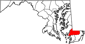 Location within the U.S. state of Maryland | |
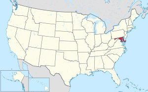 Maryland's location within the U.S. | |
| Coordinates: 38°22′N 75°38′W / 38.37°N 75.63°W | |
| Country | |
| State | |
| Founded | 1867 |
| Named for | Wicomico River |
| Seat | Salisbury |
| Largest city | Salisbury |
| Area | |
| • Total | 400 sq mi (1,000 km2) |
| • Land | 374 sq mi (970 km2) |
| • Water | 26 sq mi (70 km2) 6.4%% |
| Population (2010) | |
| • Total | 98,733 |
| • Estimate (2019) | 103,609 |
| • Density | 250/sq mi (95/km2) |
| Time zone | UTC−5 (Eastern) |
| • Summer (DST) | UTC−4 (EDT) |
| Congressional district | 1st |
| Website | www |

Wicomico County (/waɪˈkɒmɪkoʊ/[1]) is located in the southeastern part of the U.S. state of Maryland, on the Delmarva Peninsula. As of the 2010 census, the population was 98,733.[2] The county seat is Salisbury.[3] The county was named for the Wicomico River, which in turn derives from Algonquian language words wicko mekee, meaning "a place where houses are built," apparently referring to a Native American town on the banks.
Wicomico County is included in the Salisbury, MD-DE Metropolitan Statistical Area.
The newspaper of record is The Daily Times.
History[]
Wicomico County was created from Somerset and Worcester counties in 1867.
Politics and government[]
Wicomico County was granted a charter form of government in 1964.
In the period after the Reconstruction era, Wicomico County became solidly Democratic due to its strong support for secession and state efforts to disenfranchise most blacks by raising barriers to voter registration. Independent insurgent white groups worked to intimidate and discourage black voters, especially in rural areas.[4]
Maryland was a one-party state, like others in the South, until after the passage of civil rights legislation in the mid-1960s to protect the right to vote. No Republican carried Wicomico County until 1928, when Herbert Hoover won due to anti-Catholic sentiment in the heavily Protestant county against Democratic candidate Al Smith. The popular general Dwight D. Eisenhower carried Wicomico in 1952. Since the late 20th century, white conservatives, the majority in the county, have increasingly joined the Republican Party. In this same period, African-American voters have tended to favor the Democratic Party.
No Democratic presidential nominee has won Wicomico County since Lyndon Johnson’s landslide in 1964, as white conservatives increasingly moved into the Republican Party.[5] Bill Clinton, a son of the South, came within 384 votes of beating Bob Dole in 1996. Barack Obama attracted a much higher proportion of the county vote in 2008 and 2012, likely among younger people, the educated, and other minorities. In 2020, Joe Biden came extremely close to winning the county, with Donald Trump only edging him out by less than 900 votes. Biden obtained over 47.8% of the county's vote, the highest percentage for any Democrat since 1964.
| Voter Registration and Party Enrollment of Wicomico County[6] | |||||
|---|---|---|---|---|---|
| Party | Total | Percentage | |||
| Democratic | 26,769 | 42.21% | |||
| Republican | 23,425 | 36.94% | |||
| Independents, unaffiliated, and other | 13,223 | 20.85% | |||
| Total | 63,417 | 100.00% | |||
Wicomico County's government, since 2006, is that of a council-elected executive system where the voters elect members of the council and executive. Prior to 2006, the county operated under a council-administrator system where the voters elect council members and the council appoints an administrator to oversee the government.[9]
County council[]
The legislative functions of government are vested in the County Council.[10] The County Council consists of seven members, five of whom are elected from single-member districts; the other two are elected at-large.
| District | Name | Party | Role |
|---|---|---|---|
| District 1 | Ernest F. Davis | Democratic | |
| District 2 | Nicole Acle | Republican | |
| District 3 | Larry W. Dodd | Republican | President |
| District 4 | Joshua Hastings | Democratic | |
| District 5 | Joseph Holloway | Republican | Vice President |
| At-Large | John T. Cannon | Republican | |
| At-Large | William R. McCain | Democratic |
County executive[]
The County Executive[12] oversees the executive branch of the County government that consists of a number of offices and departments.[13] The executive branch is charged with implementing County law and overseeing the operation of County Government. The position of County Executive was established by a modification in the County's Charter in 2006. Day to day functions of the executive branch fall to the appointed Director of Administration, who also serves as the Acting County Executive during vacancies in the office of the County Executive.[14][15] Upon the death of Robert L. "Bob" Culver Jr., on July 26, 2020, following a 6 month battle with liver cancer,[16] the Wicomico County Council appointed then Director of Administration John D. Psota to that role in an acting capacity until the 2022 election cycle for the county executive seat.[17]
| Name | Party | From | To |
|---|---|---|---|
| Richard M. Pollitt, Jr. | Democratic | 2006 | 2014 |
| Robert L. Culver, Jr. | Republican | 2014 | 2020 |
| John D. Psota (Acting) | Republican | 2020 | 2022 |
Sheriff[]
Law enforcement in the county is provided by the Wicomico County Sheriff's Office. The sheriff, Mike Lewis, a Republican, is an elected official.[18] Municipal police agencies exist in the towns of Delmar and Pittsville, along with the cities of Fruitland and Salisbury.
State's attorney[]
The Wicomico County State's Attorney is responsible for prosecuting the felony, misdemeanor, and juvenile cases occurring in the county. The current elected State's Attorney is Jamie Dykes, Esq.[19]
Geography[]
According to the U.S. Census Bureau, the county has a total area of 400 square miles (1,000 km2), of which 374 square miles (970 km2) is land and 26 square miles (67 km2) (6.4%) is water.[20]
The county's boundary with Delaware is composed of the Mason-Dixon line and the Transpeninsular Line. The intersection of these two historical lines is the midpoint of the Transpeninsular Line, fixed by Mason and Dixon between 1763 and 1767. The midpoint is located about 8 miles (13 km) northwest of Salisbury, near the center of the Delmarva Peninsula. The county is generally flat, characteristic of the region, with a few small hills in the northeast. The lowest elevation is at sea level and the highest elevation is 98 ft (30 m).
Adjacent counties[]
- Dorchester County, Maryland (northwest)
- Somerset County, Maryland (southwest)
- Sussex County, Delaware (north)
- Worcester County, Maryland (southeast)
Major highways[]
 US 13
US 13 US 13 Bus.
 US 50
US 50 US 50 Bus.
 MD 12
MD 12 MD 54
MD 54 MD 313
 MD 346
 MD 347
 MD 348
 MD 349
 MD 350
 MD 352
 MD 353
 MD 354
 MD 374
 MD 513
 MD 670
 MD 675
 MD 815
 MD 992
Climate[]
The county has a humid subtropical climate (Cfa) according to the Köppen climate classification. According to the Trewartha climate classification, the subtropical boundary of eight months of daily averages of at least 50° F (10° C) runs through the northern part of Wicomico County. The hardiness zone is mainly 7b.
Demographics[]
| Historical population | |||
|---|---|---|---|
| Census | Pop. | %± | |
| 1870 | 15,802 | — | |
| 1880 | 18,016 | 14.0% | |
| 1890 | 19,930 | 10.6% | |
| 1900 | 22,852 | 14.7% | |
| 1910 | 26,815 | 17.3% | |
| 1920 | 28,165 | 5.0% | |
| 1930 | 31,229 | 10.9% | |
| 1940 | 34,530 | 10.6% | |
| 1950 | 39,641 | 14.8% | |
| 1960 | 49,050 | 23.7% | |
| 1970 | 54,236 | 10.6% | |
| 1980 | 64,540 | 19.0% | |
| 1990 | 74,339 | 15.2% | |
| 2000 | 84,644 | 13.9% | |
| 2010 | 98,733 | 16.6% | |
| 2019 (est.) | 103,609 | [21] | 4.9% |
| U.S. Decennial Census[22] 1790-1960[23] 1900-1990[24] 1990-2000[25] 2010–2018[2] | |||
2000 census[]
As of the census of 2000, there were 84,644 people, 32,218 households, and 21,779 families living in the county. The population density was 224 people per square mile (87/km2). There were 34,401 housing units at an average density of 91 per square mile (35/km2). The racial makeup of the county was 72.58% White, 23.29% Black or African American, 0.22% Native American, 1.75% Asian, 0.02% Pacific Islander, 0.80% from other races, and 1.34% from two or more races. 2.18% of the population were Hispanic or Latino of any race.
The largest ancestry groups in Wicomico County are 23% African American, 14% English American, 13% German, 12% Irish and 4% Italian.[26]
There were 32,218 households, out of which 32.30% had children under the age of 18 living with them, 49.20% were married couples living together, 14.10% had a female householder with no husband present, and 32.40% were non-families. 24.80% of all households were made up of individuals, and 9.80% had someone living alone who was 65 years of age or older. The average household size was 2.53 and the average family size was 3.00.
In the county the population was spread out, with 24.80% under the age of 18, 11.80% from 18 to 24, 28.00% from 25 to 44, 22.60% from 45 to 64, and 12.80% who were 65 years of age or older. The median age was 36 years. For every 100 females there were 91.00 males. For every 100 females age 18 and over, there were 86.80 males.
The median income for a household in the county was $39,035, and the median income for a family was $47,129. Males had a median income of $32,481 versus $23,548 for females. The per capita income for the county was $19,171. About 8.70% of families and 12.80% of the population were below the poverty line, including 15.60% of those under age 18 and 8.80% of those age 65 or over.
2010 census[]
As of the 2010 United States Census, there were 98,733 people, 37,220 households, and 24,172 families living in the county.[27] The population density was 263.7 inhabitants per square mile (101.8/km2). There were 41,192 housing units at an average density of 110.0 per square mile (42.5/km2).[28] The racial makeup of the county was 68.7% white, 24.2% black or African American, 2.5% Asian, 0.2% American Indian, 1.9% from other races, and 2.5% from two or more races. Those of Hispanic or Latino origin made up 4.5% of the population.[27] In terms of ancestry, 15.7% were English, 15.1% were German, 13.6% were Irish, 6.0% were American, and 5.6% were Italian.[29]
Of the 37,220 households, 32.4% had children under the age of 18 living with them, 44.9% were married couples living together, 15.2% had a female householder with no husband present, 35.1% were non-families, and 25.3% of all households were made up of individuals. The average household size was 2.53 and the average family size was 3.01. The median age was 35.7 years.[27]
The median income for a household in the county was $50,752 and the median income for a family was $62,150. Males had a median income of $42,408 versus $34,544 for females. The per capita income for the county was $25,505. About 7.8% of families and 14.3% of the population were below the poverty line, including 16.7% of those under age 18 and 8.5% of those age 65 or over.[30]
Education[]
Primary and secondary schools[]
Wicomico County Public Schools operates all public schools in the county.
Private schools[]
- Faith Baptist School
- Salisbury Baptist Academy
- St. Frances de Sales
- Salisbury Christian School
- Stepping Stones Learning Academy
- The Salisbury School
- Wicomico Day School
Colleges and universities[]
- Salisbury University
- Wor-Wic Community College
Economy[]
Perdue Farms, Inc., a multi-national poultry and grain corporation, is headquartered in Salisbury, the county seat of Wicomico County. Piedmont Airlines is headquartered in unincorporated Wicomico County,[31] at the airport and near the City of Salisbury.[32] Other major employers in Wicomico County include: Salisbury University, Verizon, Peninsula Regional Medical Center, The Knowland Group, Cadista Pharmacueticals, Chesapeake Ship Builders, Dove Pointe, and Pepsi Bottling of Delmarva.
Other industries in Wicomico County include electronic component manufacturing, pharmaceuticals, shipbuilding, and agriculture.
Media[]
Periodicals[]
- Coastal Style - bimonthly magazine
- The Daily Times - daily newspaper
- Metropolitan Magazine - monthly magazine
- Salisbury Independent - weekly newspaper
- Salisbury Star - monthly newspaper
Television[]
Salisbury is the focus city of a larger Delmarva television market, which includes Dover and the northern Eastern Shore of Virginia. Most of the market's major-network affiliates are based in Salisbury, including WBOC-TV (CBS, Telemundo, NBC, and Fox), WMDT (ABC and The CW), and Maryland Public Television station WCPB (PBS).
Communities[]
Cities[]
- Fruitland
- Salisbury (county seat)
Towns[]
Census-designated places[]
Unincorporated communities[]
- Doe Run
- Silver Run
- Wetipquin
- Whiton (partly in Worcester County)
Notable people[]
- Erin Burnett, born in Mardela Springs, CNBC host and currently host of Erin Burnett OutFront on CNN
- Joseph Stewart Cottman (1803–1863), born near Allen, United States Congressman from Maryland[33]
- Alexis Denisof, born in Salisbury, actor best known for How I Met Your Mother and Angel
- Lewis J. Fields, born in Delmar, United States Marine Corps Lieutenant General[34]
- John Glover, reared in Salisbury, actor
- Linda Hamilton, born in Salisbury, actress best known for her starring role in the television series Beauty and the Beast and the films The Terminator and Terminator 2: Judgment Day
- Maulana Karenga, born and lived in Parsonsburg, activist, author, and professor of Africana studies, best known as the creator of Kwanzaa
- Sarah Louise Northcott, convicted of murder in 1928 in Riverside County, California, and served 12 years in prison, for her role in the Wineville Chicken Coop murders—following her parole in 1940, she moved to Parsonsburg, where she resided until her death in 1944[35][self-published source]
- Frank Perdue, former president and CEO of Perdue Farms
See also[]
References[]
- ^ Weiner, Tim. "Ex-Director of C.I.A. Disappears While Canoeing on Choppy River", The New York Times, April 30, 1996. Retrieved on April 25, 2009.
- ^ Jump up to: a b "State & County QuickFacts". United States Census Bureau. Retrieved August 24, 2013.
- ^ "Find a County". National Association of Counties. Retrieved June 7, 2011.
- ^ Levine, Mark V.; "Standing Political Decisions and Critical Realignment: The Pattern of Maryland Politics, 1872-1948"; The Journal of Politics, volume 38, no. 2 (May, 1976), pp. 292-325
- ^ Sullivan, Robert David; "How the Red and Blue Map Evolved Over the Past Century"; America Magazine published in The National Catholic Review; June 29, 2016.
- ^ "Summary of Voter Activity Report" (PDF). Maryland State Board of Elections. August 2020. Retrieved October 6, 2020.
- ^ Leip, David. "Dave Leip's Atlas of U.S. Presidential Elections". uselectionatlas.org. Retrieved 2018-06-12.
- ^ "Our Campaigns - U.S. President". Retrieved January 22, 2021.
- ^ "Wicomico County Executive Race". www.wboc.com. Retrieved 2019-06-16.
- ^ "Wicomico County, MD: County Council". Wicomico County, MD Code. Retrieved 2020-07-26.
- ^ "County Council Members". Wicomico County government. Retrieved December 11, 2018.
- ^ "County Executives". Maryland State Archives. December 5, 2014. Retrieved December 8, 2014.
- ^ "Wicomico County, MD: The Executive Branch". Wicomico County, MD Code. Retrieved 2020-07-26.
- ^ "Wicomico County, MD: Director of Administration". Wicomico County, MD Code. Retrieved 2020-07-26.
- ^ "Wicomico County, MD: Vacancy in the Office of County Executive". Wicomico County, MD Code. Retrieved 2020-07-26.
- ^ "Wicomico County Executive Bob Culver Passes Away". www.wboc.com. Retrieved 2021-08-16.
- ^ Peck, Louis (2020-09-19). "Moving to End Standoff, Wicomico Council Taps County Administrator as Acting Exec". Maryland Matters. Retrieved 2021-08-17.
- ^ "Mike Lewis Sworn in as Wicomico Sheriff". Retrieved 2017-11-10.
- ^ "Coming home: Dykes ready to lay groundwork as Wicomico County interim state's attorney". Delmarva Daily Times. Retrieved 2017-11-10.
- ^ "2010 Census Gazetteer Files". United States Census Bureau. August 22, 2012. Archived from the original on September 13, 2014. Retrieved September 14, 2014.
- ^ "Population and Housing Unit Estimates". Retrieved April 26, 2019.
- ^ "U.S. Decennial Census". United States Census Bureau. Retrieved September 14, 2014.
- ^ "Historical Census Browser". University of Virginia Library. Retrieved September 14, 2014.
- ^ "Population of Counties by Decennial Census: 1900 to 1990". United States Census Bureau. Retrieved September 14, 2014.
- ^ "Census 2000 PHC-T-4. Ranking Tables for Counties: 1990 and 2000" (PDF). United States Census Bureau. Retrieved September 14, 2014.
- ^ "Wicomico County, MD Ancestry & Family History". Podunk, Inc. Archived from the original on October 4, 2013. Retrieved October 2, 2013.
- ^ Jump up to: a b c "DP-1 Profile of General Population and Housing Characteristics: 2010 Demographic Profile Data". United States Census Bureau. Archived from the original on 2020-02-13. Retrieved 2016-01-22.
- ^ "Population, Housing Units, Area, and Density: 2010 - County". United States Census Bureau. Archived from the original on 2020-02-13. Retrieved 2016-01-22.
- ^ "DP02 SELECTED SOCIAL CHARACTERISTICS IN THE UNITED STATES – 2006-2010 American Community Survey 5-Year Estimates". United States Census Bureau. Archived from the original on 2020-02-13. Retrieved 2016-01-22.
- ^ "DP03 SELECTED ECONOMIC CHARACTERISTICS – 2006-2010 American Community Survey 5-Year Estimates". United States Census Bureau. Archived from the original on 2020-02-13. Retrieved 2016-01-22.
- ^ "Career Opportunities Archived 2009-05-24 at the Wayback Machine." Piedmont Airlines. Retrieved on May 20, 2009.
- ^ "About Piedmont Archived 2009-06-27 at the Wayback Machine." Piedmont Airlines. Retrieved on May 20, 2009.
- ^ Who Was Who in America, Historical Volume, 1607-1896. Chicago: Marquis Who's Who. 1963.
- ^ "GEN. Lewis J. Fields DIES". washingtonpost.com. The Washington Posts Websites. Retrieved 7 November 2017.
- ^ Nothing is Strange with You: The Life and Crimes of Gordon Stewart Northcott. Bloomington, Indiana: Xlibris Corporation. 2008.[self-published source]
External links[]
- Wicomico County government
 Geographic data related to Wicomico County, Maryland at OpenStreetMap
- Wicomico County Convention and Visitor's Bureau
- Wicomico Public Library
- Your Community Link: A Database of Community, Government, and Non-Profit organizations on the Lower Shore
| show Places adjacent to Wicomico County, Maryland |
|---|
| show Municipalities and communities of Wicomico County, Maryland, United States |
|---|


Coordinates: 38°22′N 75°38′W / 38.37°N 75.63°W
| show Authority control |
|---|
- Maryland counties
- Wicomico County, Maryland
- 1867 establishments in Maryland
- Salisbury metropolitan area
- Populated places established in 1867
- Maryland counties on the Chesapeake Bay