Zhovti Vody
Zhovti Vody
Жовті Води | |
|---|---|
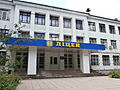
 Zhovti Vody Palace of Culture | |
 Flag  Coat of arms | |
 Zhovti Vody Location of Zhovti Vody | |
| Coordinates: 48°21′0″N 33°30′0″E / 48.35000°N 33.50000°E | |
| Country | |
| Oblast | |
| Raion | Kamianske Raion |
| Founded | 1895 |
| City | 1957 |
| Area | |
| • Total | 33.25 km2 (12.84 sq mi) |
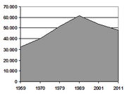
| Population (2021) | |
| • Total | 42,901 |
| • Density | 1,588/km2 (4,110/sq mi) |
| Postal code | 52290- |
| Area code(s) | +380-5652 |
| Website | zhv |

Zhovti Vody (Ukrainian: Жовті Води [ˈʒɔu̯tʲi ˈwɔdɪ]; Russian: Жёлтые Воды [ˈʐoltɨjə ˈvodɨ]; lit. ''Yellow Waters'') is a town in Kamianske Raion of south-central Ukraine's Dnipropetrovsk Oblast (province). Zhovti Vody is located on the (Ukrainian: Річка Жовта) approximately 130 km (81 mi) west of the oblast's administrative center, Dnipro. It hosts the administration of , one of the hromadas of Ukraine.[1] Population: 42,901 (2021 est.)[2].
It is a center for the extraction and processing of uranium ore.
History[]
The historic Battle of Zhovti Vody was fought on the site of the present-day city.
The area has been referred to by the term Zhovti Vody (literally "yellow waters") since before the founding of the first village on the site in 1895.
Until 18 July 2020, Zhovti Vody was incorporated as a city of oblast significance and the center of Zhovti Vody Municipality. The municipality was abolished in July 2020 as part of the administrative reform of Ukraine, which reduced the number of raions of Dnipropetrovsk Oblast to seven. The area of Zhovti Vody Municipality was merged into the newly established Kamianske Raion.[3][4]
Demographics[]
Sport[]
Gallery[]

Bus station

Mining plant building

Former factory in Zhovti Vody

"Nova" mine
Main street

Zhovti Vody Old Town

New building in Zhovti Vody

Zhovta River

Old Orthodox church
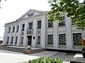
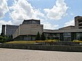
Zhovti Vody Museum of History

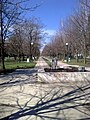
Children's park
Zhovti Vody Lycaeum

Apartment blocks in Zhovti Vody
Institute of Business Strategy

Liberation War monument

Train station Zhovti Vody


Famous People[]
- Inna Tsyganok, a professional Ukrainian triathlete
- Anastasiya Polyanskaya, a professional Russian triathlete
References[]
- ^ "Желтоводская городская громада" (in Russian). Портал об'єднаних громад України.
- ^ "Чисельність наявного населення України (Actual population of Ukraine)" (PDF) (in Ukrainian). State Statistics Service of Ukraine. Retrieved 11 July 2021.
- ^ "Про утворення та ліквідацію районів. Постанова Верховної Ради України № 807-ІХ". Голос України (in Ukrainian). 2020-07-18. Retrieved 2020-10-03.
- ^ "Нові райони: карти + склад" (in Ukrainian). Міністерство розвитку громад та територій України.
External links[]
| Wikimedia Commons has media related to Zhovti Vody. |
- (in Russian) Zhovti Vody News
- (in Ukrainian) Information Card of the City - official site of the Parliament of Ukraine
| show Authority control |
|---|
- Zhovti Vody
- Cities in Dnipropetrovsk Oblast
- Mining cities and regions in Ukraine
- Cities of regional significance in Ukraine
- Populated places established in the Russian Empire
- Former closed cities