Agnetz, Oise
Agnetz | |
|---|---|
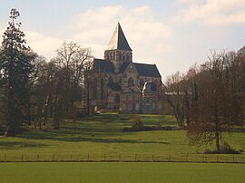 The church in Agnetz | |
 Coat of arms | |
show Location of Agnetz | |
 Agnetz | |
| Coordinates: 49°22′59″N 2°23′06″E / 49.3831°N 2.385°ECoordinates: 49°22′59″N 2°23′06″E / 49.3831°N 2.385°E | |
| Country | France |
| Region | Hauts-de-France |
| Department | Oise |
| Arrondissement | Clermont |
| Canton | Clermont |
| Intercommunality | |
| Government | |
| • Mayor (2020–2026) | Stéphanie Ansert |
| Area 1 | 12.94 km2 (5.00 sq mi) |
| Population (Jan. 2018)[1] | 3,047 |
| • Density | 240/km2 (610/sq mi) |
| Time zone | UTC+01:00 (CET) |
| • Summer (DST) | UTC+02:00 (CEST) |
| INSEE/Postal code | 60007 /60600 |
| Elevation | 52–163 m (171–535 ft) (avg. 61 m or 200 ft) |
| 1 French Land Register data, which excludes lakes, ponds, glaciers > 1 km2 (0.386 sq mi or 247 acres) and river estuaries. | |


Agnetz (French pronunciation: [aɲɛ(ts)]) is a commune in the Oise department in northern France.
Population[]
| Year | Pop. | ±% |
|---|---|---|
| 2004 | 2,801 | — |
| 2006 | 2,807 | +0.2% |
| 2007 | 2,842 | +1.2% |
| 2008 | 2,882 | +1.4% |
| 2009 | 2,922 | +1.4% |
| 2010 | 2,960 | +1.3% |
| 2011 | 2,965 | +0.2% |
| 2012 | 2,977 | +0.4% |
| 2013 | 2,987 | +0.3% |
| 2014 | 2,997 | +0.3% |
| 2015 | 3,073 | +2.5% |
| 2016 | 3,050 | −0.7% |
Heraldry[]
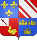 |
The arms of the commune of Agnetz are blazoned : Quarterly, 1: Azure, 3 fleurs-de-lys Or; 2: Gules, a bend coticed argent; 3: Gules, a martlet Or and on a canton argent a dagger inverted bendwise gules; 4: Azure, 3 triple-towered castles Or.
|
See also[]
References[]
- ^ "Populations légales 2018". INSEE. 28 December 2020.
| Wikimedia Commons has media related to Agnetz. |
This Oise geographical article is a stub. You can help Wikipedia by . |
Categories:
- Communes of Oise
- Oise geography stubs