Anaa Airport
Anaa Airport Aérodrome de Anaa | |||||||||||
|---|---|---|---|---|---|---|---|---|---|---|---|
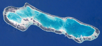 NASA picture of Anaa Atoll | |||||||||||
| Summary | |||||||||||
| Airport type | Public | ||||||||||
| Operator | DSEAC Polynésie Française | ||||||||||
| Serves | Anaa | ||||||||||
| Location | , French Polynesia | ||||||||||
| Elevation AMSL | 10 ft / 3 m | ||||||||||
| Coordinates | 17°20′56″S 145°30′44″W / 17.34889°S 145.51222°WCoordinates: 17°20′56″S 145°30′44″W / 17.34889°S 145.51222°W | ||||||||||
| Map | |||||||||||
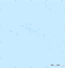 AAA Location of the airport in French Polynesia | |||||||||||
| Runways | |||||||||||
| |||||||||||

[3]Anaa Airport (IATA: AAA, ICAO: NTGA) is an airport serving Anaa, an atoll in the Tuamotu archipelago in French Polynesia. It is located 2 kilometres (1.2 mi) southeast of the village of Tukuhora.[2] The airport type is medium and the World Area Code is 823.[4] The nearest airport (76.22 km) is Faaite Airport. The airport is recorded to be 3m above sea level and contains a runway of length 1500m.[5]
Airlines and destinations[]
Passenger[]
No scheduled flight as of May 2019.[6]
See also[]
References[]
- ^ "Airport information for NTGA". World Aero Data. Archived from the original on 2019-03-05.
{{cite web}}: CS1 maint: unfit URL (link) Data current as of October 2006. Source: DAFIF. - ^ a b NTGA – Anaa. AIP from French Service d'information aéronautique, effective 27 January 2022.
- ^ "Handy Anaa airport information from Skyscanner". www.skyscanner.com.au. Retrieved 2019-04-14.
- ^ "Anaa - French Polynesia". World Airport Codes. Retrieved 2019-04-14.
- ^ "Anaa airport (AAA), Anaa, French Polynesia". airports-list.com. Retrieved 2019-04-27.
- ^ "Download forecast schedule - Official website - Air Tahiti".
External links[]
This article about an Oceanian airport is a stub. You can help Wikipedia by . |
This French Polynesia-related geography article is a stub. You can help Wikipedia by . |
Categories:
- Airports in French Polynesia
- Oceanian airport stubs
- French Polynesia geography stubs