Andeville
Andeville | |
|---|---|
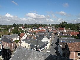 View from the roof of the village church | |
show Location of Andeville | |
 Andeville | |
| Coordinates: 49°15′37″N 2°09′57″E / 49.2603°N 2.1658°ECoordinates: 49°15′37″N 2°09′57″E / 49.2603°N 2.1658°E | |
| Country | France |
| Region | Hauts-de-France |
| Department | Oise |
| Arrondissement | Beauvais |
| Canton | Méru |
| Intercommunality | |
| Government | |
| • Mayor (2020–2026) | Jean-Charles Morel[1] |
| Area 1 | 4.17 km2 (1.61 sq mi) |
| Population (Jan. 2018)[2] | 3,292 |
| • Density | 790/km2 (2,000/sq mi) |
| Time zone | UTC+01:00 (CET) |
| • Summer (DST) | UTC+02:00 (CEST) |
| INSEE/Postal code | 60012 /60570 |
| Elevation | 122–178 m (400–584 ft) (avg. 150 m or 490 ft) |
| 1 French Land Register data, which excludes lakes, ponds, glaciers > 1 km2 (0.386 sq mi or 247 acres) and river estuaries. | |


Andeville (French pronunciation: [ɑ̃dvil]) is a commune in the Oise department in northern France.
Population[]
|
|
See also[]
References[]
- ^ "Répertoire national des élus: les maires". data.gouv.fr, Plateforme ouverte des données publiques françaises (in French). 2 December 2020.
- ^ "Populations légales 2018". INSEE. 28 December 2020.
External links[]
| Wikimedia Commons has media related to Andeville. |
This Oise geographical article is a stub. You can help Wikipedia by . |
Categories:
- Communes of Oise
- Oise geography stubs