Ars-sur-Moselle
Ars-sur-Moselle | |
|---|---|
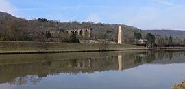 The river and a section of aqueduct in Ars-sur-Moselle | |
 Coat of arms | |
show Location of Ars-sur-Moselle | |
 Ars-sur-Moselle | |
| Coordinates: 49°04′44″N 6°04′30″E / 49.0789°N 6.075°ECoordinates: 49°04′44″N 6°04′30″E / 49.0789°N 6.075°E | |
| Country | France |
| Region | Grand Est |
| Department | Moselle |
| Arrondissement | Metz |
| Canton | Les Coteaux de Moselle |
| Intercommunality | Metz Métropole |
| Government | |
| • Mayor (2020–2026) | Bruno Valdevit[1] |
| Area 1 | 11.6 km2 (4.5 sq mi) |
| Population (Jan. 2018)[2] | 4,714 |
| • Density | 410/km2 (1,100/sq mi) |
| Time zone | UTC+01:00 (CET) |
| • Summer (DST) | UTC+02:00 (CEST) |
| INSEE/Postal code | 57032 /57130 |
| Elevation | 165–344 m (541–1,129 ft) (avg. 174 m or 571 ft) |
| 1 French Land Register data, which excludes lakes, ponds, glaciers > 1 km2 (0.386 sq mi or 247 acres) and river estuaries. | |


Ars-sur-Moselle (German: Ars an der Mosel) is a commune in the Moselle department in Grand Est in northeastern France.
History[]
Ars-sur-Moselle was a part of Germany, in the imperial territory of Alsace-Lorraine,[3] from 1871 to 1918. It was called Ars-an-der-Mosel in German.
Sights[]
The town has a handsome Roman Catholic church. In the vicinity are the remains of a Roman aqueduct, which formerly spanned the valley.[3]
Population[]
|
|
See also[]
References[]
- ^ "Répertoire national des élus: les maires". data.gouv.fr, Plateforme ouverte des données publiques françaises (in French). 2 December 2020.
- ^ "Populations légales 2018". INSEE. 28 December 2020.
- ^ Jump up to: a b One or more of the preceding sentences incorporates text from a publication now in the public domain: Chisholm, Hugh, ed. (1911). "Ars-an-der-Mosel". Encyclopædia Britannica. 2 (11th ed.). Cambridge University Press. p. 650.
| Wikimedia Commons has media related to Ars-sur-Moselle. |
| show Authority control |
|---|
Categories:
- Communes of Moselle (department)
- Metz arrondissement geography stubs