Bairols
Bairols | |
|---|---|
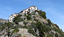 A general view of the village | |
 Coat of arms | |
show Location of Bairols | |
 Bairols | |
| Coordinates: 43°58′57″N 7°07′41″E / 43.9825°N 7.1281°ECoordinates: 43°58′57″N 7°07′41″E / 43.9825°N 7.1281°E | |
| Country | France |
| Region | Provence-Alpes-Côte d'Azur |
| Department | Alpes-Maritimes |
| Arrondissement | Nice |
| Canton | Vence |
| Intercommunality | Métropole Nice Côte d'Azur |
| Government | |
| • Mayor (2020–2026) | Angelin Buerch[1] |
| Area 1 | 15.24 km2 (5.88 sq mi) |
| Population (Jan. 2018)[2] | 107 |
| • Density | 7.0/km2 (18/sq mi) |
| Time zone | UTC+01:00 (CET) |
| • Summer (DST) | UTC+02:00 (CEST) |
| INSEE/Postal code | 06009 /06420 |
| Elevation | 280–1,803 m (919–5,915 ft) (avg. 880 m or 2,890 ft) |
| 1 French Land Register data, which excludes lakes, ponds, glaciers > 1 km2 (0.386 sq mi or 247 acres) and river estuaries. | |


Bairols (Occitan: Bairòls) is a commune in the Alpes-Maritimes department in the Provence-Alpes-Côte d'Azur region of south-eastern France.
The inhabitants of the commune are known as Bairolois or Bairoloises.[3]
The commune has been awarded two flowers by the National Council of Towns and Villages in Bloom in the Competition of cities and villages in Bloom.[4]
Geography[]
Bairols is located at an altitude of 830 metres on a rocky ridge some 20 km north of Gilette and 5 km north of Villars-sur-Var. Access to the commune is by the M26 road from Tournefort in the south which passes through the south-eastern corner of the commune and connects with the tortuous M56 road which continues to the village. The commune is a rugged alpine commune.[5]
The Tinée river forms the eastern border of the commune as it flows south to join the Var. Many tributaries rise in the commune and flow east to join the Tinée including the Vallon du Serre, the Ruisseau de Fava, the Vallon du Bairols, and the Ravin de Saint Martin.[5]
Neighbouring communes and villages[]
| show Places adjacent to Bairols |
|---|
History[]
The name Bairolum is cited around 1040. The village was then given to Lérins Abbey then became a fief of the Grimaldi.
The village was linked to the outside world by a motorable road in 1939. There were still 257 inhabitants in 1858.
Heraldry[]
 |
The official status of the blazon remains to be determined.
Blazon:
|
Administration[]

This list is incomplete; you can help by . (April 2021) |
| From | To | Name | Party |
|---|---|---|---|
| 2001 | Current | Angelin Buerch | DVD |
Population[]
| Year | Pop. | ±% |
|---|---|---|
| 2004 | 109 | — |
| 2006 | 103 | −5.5% |
| 2007 | 104 | +1.0% |
| 2008 | 105 | +1.0% |
| 2009 | 106 | +1.0% |
| 2010 | 107 | +0.9% |
| 2011 | 109 | +1.9% |
| 2012 | 108 | −0.9% |
| 2013 | 107 | −0.9% |
| 2014 | 106 | −0.9% |
| 2015 | 105 | −0.9% |
| 2016 | 104 | −1.0% |

Sites and Monuments[]


- Ruins of a Chateau
- The Medieval Church of Sainte-Marguerite whose "S" form is due to the topography. Inside there are two frescoes in the choir on the theme of the Baptism of Christ. The church has a painting by Jean Rocca of the Virgin of the Rosary and Mysteries dated 1645.[7][8] The church also contains a Group Sculpture on a Processional dais of Saint Marguerite and the Tarasque (18th century)
 which is registered as an historical object.[9]
 - The Chapel of Saint Antoine above the village
- The Chapel of Saint-Roch, above, built around 1750
- Remains of the Chapel of Saint-Martin
- Two former oil and grain mills
- The remains of the old village below the present village.
See also[]
References[]
- ^ "Répertoire national des élus: les maires". data.gouv.fr, Plateforme ouverte des données publiques françaises (in French). 2 December 2020.
- ^ "Populations légales 2018". INSEE. 28 December 2020.
- ^ Inhabitants of Alpes-Maritimes (in French)
- ^ Bairols in the Competition for Towns and Villages in Bloom Archived December 10, 2014, at the Wayback Machine (in French)
- ^ Jump up to: a b c Google Maps
- ^ List of Mayors of France (in French)
- ^ Charles Astro, Luc F. Thévenon, Painting in the 17th century in the Southern Alps, p. 58, éditions Serre (collection Patrimoines), Nice, 1985 ISBN 2-86410-048-7 (in French)
- ^ Christiane Lorgues-Lapouge, René Lorgues, Baroque County of Nice - Volume 1: The Tinée Valley, p. 27-31, Encyclopædia Niciensis, Volume V, Serre éditeur, Nice, 2004 ISBN 2-86410-416-4; p. 99 (in French)
- ^ Ministry of Culture, Palissy PM06001491 Group Sculpture on a Processional dais: Saint Marguerite and the Tarasque (in French)
Bibliography[]
- Philippe de Beauchamp, The misunderstood High Country. Isolated Villages and Hamlets of Alpes-Marities, p. 81, éditions Serre, Nice, 1989, ISBN 2-86410-131-9; p. 159 (in French)
External links[]
| Wikimedia Commons has media related to Bairols. |
- Communes of Alpes-Maritimes