Spéracèdes
show This article may be expanded with text translated from the corresponding article in French. (December 2008) Click [show] for important translation instructions. |
Spéracèdes | |
|---|---|
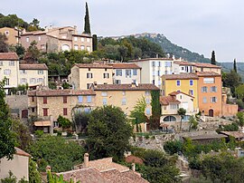 View of the village towards Cabris | |
 Coat of arms | |
show Location of Spéracèdes | |
 Spéracèdes | |
| Coordinates: 43°38′58″N 6°51′34″E / 43.6494°N 6.8594°ECoordinates: 43°38′58″N 6°51′34″E / 43.6494°N 6.8594°E | |
| Country | France |
| Region | Provence-Alpes-Côte d'Azur |
| Department | Alpes-Maritimes |
| Arrondissement | Grasse |
| Canton | Grasse-1 |
| Intercommunality | CA Pays de Grasse |
| Government | |
| • Mayor (2020–2026) | Jean-Marc Macario[1] |
| Area 1 | 3.46 km2 (1.34 sq mi) |
| Population (Jan. 2018)[2] | 1,213 |
| • Density | 350/km2 (910/sq mi) |
| Time zone | UTC+01:00 (CET) |
| • Summer (DST) | UTC+02:00 (CEST) |
| INSEE/Postal code | 06137 /06530 |
| Elevation | 204–790 m (669–2,592 ft) (avg. 390 m or 1,280 ft) |
| 1 French Land Register data, which excludes lakes, ponds, glaciers > 1 km2 (0.386 sq mi or 247 acres) and river estuaries. | |


Spéracèdes (French pronunciation: [speʁasɛd]; Occitan: Las Perascedas) is a commune in the Alpes-Maritimes department in southeastern France.
Population[]
Residents are called "Spéracèdois".
| Year | Pop. | ±% |
|---|---|---|
| 1962 | 440 | — |
| 1968 | 531 | +20.7% |
| 1975 | 674 | +26.9% |
| 1982 | 764 | +13.4% |
| 1990 | 1,029 | +34.7% |
| 1999 | 1,095 | +6.4% |
| 2008 | 1,191 | +8.8% |
See also[]
References[]
- ^ "Répertoire national des élus: les maires". data.gouv.fr, Plateforme ouverte des données publiques françaises (in French). 2 December 2020.
- ^ "Populations légales 2018". INSEE. 28 December 2020.
External links[]
- Commune's official website
- Commune's events, life, and news : "Spéracèdes Demain" association's website
| Wikimedia Commons has media related to Spéracèdes. |
This Alpes-Maritimes geographical article is a stub. You can help Wikipedia by . |
Categories:
- Communes of Alpes-Maritimes
- Alpes-Maritimes geography stubs