Roquebillière
show This article may be expanded with text translated from the corresponding article in French. (December 2008) Click [show] for important translation instructions. |
Roquebillière | |
|---|---|
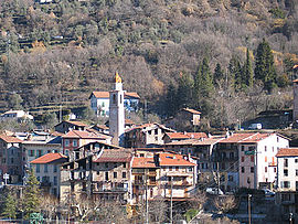 A general view of the village, with the belfry in the middle | |
 Coat of arms | |
show Location of Roquebillière | |
 Roquebillière | |
| Coordinates: 44°00′43″N 7°18′27″E / 44.0119°N 07.3075°ECoordinates: 44°00′43″N 7°18′27″E / 44.0119°N 07.3075°E | |
| Country | France |
| Region | Provence-Alpes-Côte d'Azur |
| Department | Alpes-Maritimes |
| Arrondissement | Nice |
| Canton | Tourrette-Levens |
| Intercommunality | Métropole Nice Côte d'Azur |
| Government | |
| • Mayor (2020–2026) | Gérard Manfredi[1] |
| Area 1 | 25.92 km2 (10.01 sq mi) |
| Population (Jan. 2018)[2] | 1,836 |
| • Density | 71/km2 (180/sq mi) |
| Time zone | UTC+01:00 (CET) |
| • Summer (DST) | UTC+02:00 (CEST) |
| INSEE/Postal code | 06103 /06450 |
| Elevation | 500–2,045 m (1,640–6,709 ft) |
| 1 French Land Register data, which excludes lakes, ponds, glaciers > 1 km2 (0.386 sq mi or 247 acres) and river estuaries. | |


Roquebillière (French pronunciation: [ʁɔkbiljɛʁ]; historical Italian: Roccabigliera; Occitan: Ròcabilhiera) is a commune in the Alpes-Maritimes department in southeastern France.
History[]
It was part of the historic County of Nice until 1860 as Roccabigliere." The town was at one time a Templar settlement.
Population[]
| Year | Pop. | ±% |
|---|---|---|
| 1962 | 1,377 | — |
| 1968 | 1,426 | +3.6% |
| 1975 | 1,336 | −6.3% |
| 1982 | 1,504 | +12.6% |
| 1990 | 1,539 | +2.3% |
| 1999 | 1,467 | −4.7% |
| 2008 | 1,636 | +11.5% |
See also[]
References[]
- ^ "Répertoire national des élus: les maires". data.gouv.fr, Plateforme ouverte des données publiques françaises (in French). 2 December 2020. Retrieved 7 December 2020.
- ^ "Populations légales 2018". INSEE. 28 December 2020.
External links[]
- (in English and French) & (Occitan) Dance and traditional music from Roquebillière
| Wikimedia Commons has media related to Roquebillière. |
| Authority control |
|
|---|
This Alpes-Maritimes geographical article is a stub. You can help Wikipedia by . |
Categories:
- Communes of Alpes-Maritimes
- Alpes-Maritimes geography stubs