Saint-Jeannet, Alpes-Maritimes
show This article may be expanded with text translated from the corresponding article in French. (December 2008) Click [show] for important translation instructions. |
Saint-Jeannet | |
|---|---|
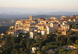 The old village of Saint-Jeannet | |
 Coat of arms | |
show Location of Saint-Jeannet | |
 Saint-Jeannet | |
| Coordinates: 43°44′50″N 7°08′38″E / 43.7472°N 7.1439°ECoordinates: 43°44′50″N 7°08′38″E / 43.7472°N 7.1439°E | |
| Country | France |
| Region | Provence-Alpes-Côte d'Azur |
| Department | Alpes-Maritimes |
| Arrondissement | Grasse |
| Canton | Vence |
| Intercommunality | Métropole Nice Côte d'Azur |
| Government | |
| • Mayor (2020–2026) | Julie Charles[1] |
| Area 1 | 14.58 km2 (5.63 sq mi) |
| Population (Jan. 2018)[2] | 4,157 |
| • Density | 290/km2 (740/sq mi) |
| Time zone | UTC+01:00 (CET) |
| • Summer (DST) | UTC+02:00 (CEST) |
| INSEE/Postal code | 06122 /06640 |
| Elevation | 39–934 m (128–3,064 ft) (avg. 400 m or 1,300 ft) |
| 1 French Land Register data, which excludes lakes, ponds, glaciers > 1 km2 (0.386 sq mi or 247 acres) and river estuaries. | |


Saint-Jeannet (Occitan: Sant Joanet) is a commune in the Alpes-Maritimes department in southeastern France.
Population[]
| Year | Pop. | ±% |
|---|---|---|
| 1962 | 1,079 | — |
| 1968 | 1,421 | +31.7% |
| 1975 | 1,843 | +29.7% |
| 1982 | 2,436 | +32.2% |
| 1990 | 3,188 | +30.9% |
| 1999 | 3,594 | +12.7% |
| 2008 | 3,656 | +1.7% |
Tourism[]
Saint-Jeannet is one of sixteen villages grouped together by the Métropole Nice Côte d'Azur tourist department as the Route des Villages Perchés (Route of Perched Villages). The others are: Aspremont, Carros, Castagniers, Coaraze, Colomars, Duranus, Èze, Falicon, La Gaude, Lantosque, Levens, La Roquette-sur-Var, Saint-Blaise, Tourrette-Levens and Utelle.[3]
See also[]
References[]
- ^ "Répertoire national des élus: les maires". data.gouv.fr, Plateforme ouverte des données publiques françaises (in French). 2 December 2020.
- ^ "Populations légales 2018". INSEE. 28 December 2020.
- ^ "The route of perched villages" (PDF). Métropole Nice Côte d'Azur. 2013.
| Wikimedia Commons has media related to Saint-Jeannet, Alpes-Maritimes. |
| show Authority control |
|---|
This Alpes-Maritimes geographical article is a stub. You can help Wikipedia by . |
Categories:
- Communes of Alpes-Maritimes
- Alpes-Maritimes geography stubs