Rigaud, Alpes-Maritimes
show This article may be expanded with text translated from the corresponding article in French. (December 2008) Click [show] for important translation instructions. |
Rigaud | |
|---|---|
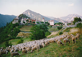 A flock of sheep outside Rigaud village | |
 Coat of arms | |
show Location of Rigaud | |
 Rigaud | |
| Coordinates: 43°59′30″N 6°59′31″E / 43.9917°N 6.9919°ECoordinates: 43°59′30″N 6°59′31″E / 43.9917°N 6.9919°E | |
| Country | France |
| Region | Provence-Alpes-Côte d'Azur |
| Department | Alpes-Maritimes |
| Arrondissement | Nice |
| Canton | Vence |
| Government | |
| • Mayor (2020–2026) | Francis Moya[1] |
| Area 1 | 32.54 km2 (12.56 sq mi) |
| Population (Jan. 2018)[2] | 197 |
| • Density | 6.1/km2 (16/sq mi) |
| Time zone | UTC+01:00 (CET) |
| • Summer (DST) | UTC+02:00 (CEST) |
| INSEE/Postal code | 06101 /06260 |
| Elevation | 333–1,907 m (1,093–6,257 ft) (avg. 753 m or 2,470 ft) |
| 1 French Land Register data, which excludes lakes, ponds, glaciers > 1 km2 (0.386 sq mi or 247 acres) and river estuaries. | |


Rigaud is a commune in the Alpes-Maritimes department in southeastern France.
Geography[]
The commune is traversed by the Cians, the Cianavelle and the Raton Rivers.
Population[]
| Year | Pop. | ±% |
|---|---|---|
| 1962 | 117 | — |
| 1968 | 117 | +0.0% |
| 1975 | 111 | −5.1% |
| 1982 | 141 | +27.0% |
| 1990 | 165 | +17.0% |
| 1999 | 146 | −11.5% |
| 2008 | 210 | +43.8% |

In the gorges du Cians.
See also[]
References[]
- ^ "Répertoire national des élus: les maires". data.gouv.fr, Plateforme ouverte des données publiques françaises (in French). 2 December 2020.
- ^ "Populations légales 2018". INSEE. 28 December 2020.
| Wikimedia Commons has media related to Rigaud, Alpes-Maritimes. |
This Alpes-Maritimes geographical article is a stub. You can help Wikipedia by . |
Categories:
- Communes of Alpes-Maritimes
- Alpes-Maritimes geography stubs