Châteauneuf-d'Entraunes
show This article may be expanded with text translated from the corresponding article in French. (December 2008) Click [show] for important translation instructions. |
Châteauneuf-d'Entraunes | |
|---|---|
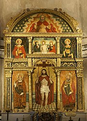 Altarpiece | |
 Coat of arms | |
show Location of Châteauneuf-d'Entraunes | |
 Châteauneuf-d'Entraunes | |
| Coordinates: 44°07′45″N 6°49′58″E / 44.1292°N 6.8328°ECoordinates: 44°07′45″N 6°49′58″E / 44.1292°N 6.8328°E | |
| Country | France |
| Region | Provence-Alpes-Côte d'Azur |
| Department | Alpes-Maritimes |
| Arrondissement | Nice |
| Canton | Vence |
| Government | |
| • Mayor (2020–2026) | Jocelyne Baruffa[1] |
| Area 1 | 29.91 km2 (11.55 sq mi) |
| Population (Jan. 2018)[2] | 63 |
| • Density | 2.1/km2 (5.5/sq mi) |
| Time zone | UTC+01:00 (CET) |
| • Summer (DST) | UTC+02:00 (CEST) |
| INSEE/Postal code | 06040 /06470 |
| Elevation | 880–2,813 m (2,887–9,229 ft) (avg. 1,282 m or 4,206 ft) |
| 1 French Land Register data, which excludes lakes, ponds, glaciers > 1 km2 (0.386 sq mi or 247 acres) and river estuaries. | |


Châteauneuf-d'Entraunes (Occitan: Chasternòu d'Entraunas) is a commune in the Alpes-Maritimes department in southeastern France. It is situated in the Val d'Entraunes, the upper valley of the river Var. It lies partly within the Mercantour National Park. The church of Saint-Nicolas houses a 16th-century altarpiece, attributed to .[3]
Population[]
| Year | Pop. | ±% |
|---|---|---|
| 1962 | 44 | — |
| 1968 | 19 | −56.8% |
| 1975 | 36 | +89.5% |
| 1982 | 47 | +30.6% |
| 1990 | 71 | +51.1% |
| 1999 | 56 | −21.1% |
| 2008 | 68 | +21.4% |
See also[]
References[]
- ^ "Répertoire national des élus: les maires". data.gouv.fr, Plateforme ouverte des données publiques françaises (in French). 2 December 2020.
- ^ "Populations légales 2018". INSEE. 28 December 2020.
- ^ Base Palissy: Autel, retable, 7 tableaux : le Christ aux cinq plaies, Ministère français de la Culture. (in French)
| Wikimedia Commons has media related to Châteauneuf-d'Entraunes. |
This Alpes-Maritimes geographical article is a stub. You can help Wikipedia by . |
Categories:
- Communes of Alpes-Maritimes
- Alpes-Maritimes geography stubs