Moulinet, Alpes-Maritimes
show This article may be expanded with text translated from the corresponding article in French. (December 2008) Click [show] for important translation instructions. |
Moulinet | |
|---|---|
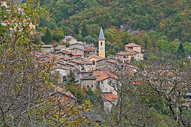 A view of the village of Moulinet from the trail of Saint Michel | |
 Coat of arms | |
show Location of Moulinet | |
 Moulinet | |
| Coordinates: 43°56′30″N 7°24′48″E / 43.9417°N 07.4133°ECoordinates: 43°56′30″N 7°24′48″E / 43.9417°N 07.4133°E | |
| Country | France |
| Region | Provence-Alpes-Côte d'Azur |
| Department | Alpes-Maritimes |
| Arrondissement | Nice |
| Canton | Contes |
| Intercommunality | Riviera française |
| Government | |
| • Mayor (2020–2026) | Guy Bonvallet[1] |
| Area 1 | 41.07 km2 (15.86 sq mi) |
| Population (Jan. 2018)[2] | 262 |
| • Density | 6.4/km2 (17/sq mi) |
| Time zone | UTC+01:00 (CET) |
| • Summer (DST) | UTC+02:00 (CEST) |
| INSEE/Postal code | 06086 /06380 |
| Elevation | 516–2,080 m (1,693–6,824 ft) |
| 1 French Land Register data, which excludes lakes, ponds, glaciers > 1 km2 (0.386 sq mi or 247 acres) and river estuaries. | |


Moulinet is a commune in the Alpes-Maritimes department in southeastern France.
Population[]
| Year | Pop. | ±% |
|---|---|---|
| 1968 | 265 | — |
| 1975 | 220 | −17.0% |
| 1982 | 164 | −25.5% |
| 1990 | 193 | +17.7% |
| 1999 | 249 | +29.0% |
| 2008 | 216 | −13.3% |
See also[]
References[]
- ^ "Répertoire national des élus: les maires". data.gouv.fr, Plateforme ouverte des données publiques françaises (in French). 2 December 2020.
- ^ "Populations légales 2018". INSEE. 28 December 2020.
External links[]
| Wikimedia Commons has media related to Moulinet, Alpes-Maritimes. |
This Alpes-Maritimes geographical article is a stub. You can help Wikipedia by . |
Categories:
- Communes of Alpes-Maritimes
- Alpes-Maritimes geography stubs