La Penne
show This article may be expanded with text translated from the corresponding article in French. (December 2008) Click [show] for important translation instructions. |
La Penne | |
|---|---|
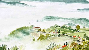
 A general view of the village | |
 Coat of arms | |
show Location of La Penne | |
 La Penne | |
| Coordinates: 43°55′40″N 6°56′53″E / 43.92790°N 6.948°ECoordinates: 43°55′40″N 6°56′53″E / 43.92790°N 6.948°E | |
| Country | France |
| Region | Provence-Alpes-Côte d'Azur |
| Department | Alpes-Maritimes |
| Arrondissement | Nice |
| Canton | Vence |
| Government | |
| • Mayor (2020–2026) | Loïc Daumas[1] |
| Area 1 | 18.08 km2 (6.98 sq mi) |
| Population (Jan. 2018)[2] | 214 |
| • Density | 12/km2 (31/sq mi) |
| Time zone | UTC+01:00 (CET) |
| • Summer (DST) | UTC+02:00 (CEST) |
| INSEE/Postal code | 06093 /06260 |
| Elevation | 520–1,436 m (1,706–4,711 ft) (avg. 800 m or 2,600 ft) |
| 1 French Land Register data, which excludes lakes, ponds, glaciers > 1 km2 (0.386 sq mi or 247 acres) and river estuaries. | |


La Penne (French pronunciation: [la pɛn]; Occitan: La Pena) is a commune in the Alpes-Maritimes department in southeastern France.
Population[]
| Year | Pop. | ±% |
|---|---|---|
| 1962 | 117 | — |
| 1968 | 124 | +6.0% |
| 1975 | 116 | −6.5% |
| 1982 | 120 | +3.4% |
| 1990 | 145 | +20.8% |
| 1999 | 164 | +13.1% |
| 2008 | 302 | +84.1% |
See also[]
References[]
- ^ "Répertoire national des élus: les maires". data.gouv.fr, Plateforme ouverte des données publiques françaises (in French). 2 December 2020.
- ^ "Populations légales 2018". INSEE. 28 December 2020.
External links[]
Route du Chanan in the mist.
| Wikimedia Commons has media related to La Penne. |
This Alpes-Maritimes geographical article is a stub. You can help Wikipedia by . |
Categories:
- Communes of Alpes-Maritimes
- Alpes-Maritimes geography stubs