Le Tignet
show This article may be expanded with text translated from the corresponding article in French. (December 2008) Click [show] for important translation instructions. |
Le Tignet | |
|---|---|
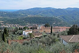 A view of the village of Le Tignet from a property on the path of Léouvière | |
 Coat of arms | |
show Location of Le Tignet | |
 Le Tignet | |
| Coordinates: 43°38′29″N 6°50′47″E / 43.6414°N 6.8464°ECoordinates: 43°38′29″N 6°50′47″E / 43.6414°N 6.8464°E | |
| Country | France |
| Region | Provence-Alpes-Côte d'Azur |
| Department | Alpes-Maritimes |
| Arrondissement | Grasse |
| Canton | Grasse-1 |
| Intercommunality | CA Pays de Grasse |
| Government | |
| • Mayor (2020–2026) | Claude Serra[1] |
| Area 1 | 11.26 km2 (4.35 sq mi) |
| Population (Jan. 2018)[2] | 3,063 |
| • Density | 270/km2 (700/sq mi) |
| Time zone | UTC+01:00 (CET) |
| • Summer (DST) | UTC+02:00 (CEST) |
| INSEE/Postal code | 06140 /06530 |
| Elevation | 30–600 m (98–1,969 ft) (avg. 325 m or 1,066 ft) |
| 1 French Land Register data, which excludes lakes, ponds, glaciers > 1 km2 (0.386 sq mi or 247 acres) and river estuaries. | |


Le Tignet (French pronunciation: [lə tiɲɛ]; Occitan: Lo Tinhet) is a commune in the Alpes-Maritimes department in the Provence-Alpes-Côte d'Azur region of south-eastern France.
The inhabitants of the commune are known as Tignétans.
Population[]
| Year | Pop. | ±% |
|---|---|---|
| 1962 | 267 | — |
| 1968 | 397 | +48.7% |
| 1975 | 643 | +62.0% |
| 1982 | 1,123 | +74.7% |
| 1990 | 1,945 | +73.2% |
| 1999 | 2,763 | +42.1% |
| 2008 | 3,099 | +12.2% |
See also[]
References[]
- ^ "Répertoire national des élus: les maires". data.gouv.fr, Plateforme ouverte des données publiques françaises (in French). 2 December 2020.
- ^ "Populations légales 2018". INSEE. 28 December 2020.
| Wikimedia Commons has media related to Le Tignet. |
This Alpes-Maritimes geographical article is a stub. You can help Wikipedia by . |
Categories:
- Communes of Alpes-Maritimes
- Alpes-Maritimes geography stubs