Bel-Air-Val-d'Ance
Bel-Air-Val-d'Ance | |
|---|---|
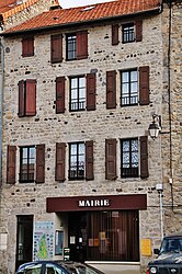 The town hall in Chambon-le-Château | |
Location of Bel-Air-Val-d'Ance  | |
 Bel-Air-Val-d'Ance | |
| Coordinates: 44°51′14″N 3°39′37″E / 44.8539°N 3.6603°ECoordinates: 44°51′14″N 3°39′37″E / 44.8539°N 3.6603°E | |
| Country | France |
| Region | Occitanie |
| Department | Lozère |
| Arrondissement | Mende |
| Canton | Grandrieu |
| Intercommunality | Haut Allier |
| Area 1 | 41.40 km2 (15.98 sq mi) |
| Population (Jan. 2018)[1] | 534 |
| • Density | 13/km2 (33/sq mi) |
| Time zone | UTC+01:00 (CET) |
| • Summer (DST) | UTC+02:00 (CEST) |
| INSEE/Postal code | 48038 /48600 |
| Elevation | 891–1,237 m (2,923–4,058 ft) (avg. 1,000 m or 3,300 ft) |
| 1 French Land Register data, which excludes lakes, ponds, glaciers > 1 km2 (0.386 sq mi or 247 acres) and river estuaries. | |


Bel-Air-Val-d'Ance is a commune in the Lozère department in southern France. It was established on 1 January 2019 by merger of the former communes of Chambon-le-Château (the seat) and Saint-Symphorien.[2]
See also[]
References[]
- ^ "Populations légales 2018". The National Institute of Statistics and Economic Studies. 28 December 2020.
- ^ Arrêté préfectoral 28 September 2018, p. 131 (in French)
| Wikimedia Commons has media related to Bel-Air-Val-d'Ance. |
This Lozère geographical article is a stub. You can help Wikipedia by . |
Categories:
- Communes of Lozère
- Populated places established in 2019
- 2019 establishments in France
- Lozère geography stubs