Saint-Léger-du-Malzieu
Saint-Léger-du-Malzieu | |
|---|---|
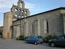 The church of Saint-Barthélémy, in Saint-Léger-du-Malzieu | |
show Location of Saint-Léger-du-Malzieu | |
 Saint-Léger-du-Malzieu | |
| Coordinates: 44°53′19″N 3°18′38″E / 44.8886°N 3.3106°ECoordinates: 44°53′19″N 3°18′38″E / 44.8886°N 3.3106°E | |
| Country | France |
| Region | Occitanie |
| Department | Lozère |
| Arrondissement | Mende |
| Canton | Saint-Alban-sur-Limagnole |
| Intercommunality | Terres d'Apcher-Margeride-Aubrac |
| Government | |
| • Mayor (2020–2026) | Ludovic Jaffuel[1] |
| Area 1 | 18.92 km2 (7.31 sq mi) |
| Population (Jan. 2018)[2] | 212 |
| • Density | 11/km2 (29/sq mi) |
| Time zone | UTC+01:00 (CET) |
| • Summer (DST) | UTC+02:00 (CEST) |
| INSEE/Postal code | 48169 /48140 |
| Elevation | 797–1,184 m (2,615–3,885 ft) (avg. 859 m or 2,818 ft) |
| 1 French Land Register data, which excludes lakes, ponds, glaciers > 1 km2 (0.386 sq mi or 247 acres) and river estuaries. | |


Saint-Léger-du-Malzieu (French pronunciation: [sɛ̃ leʒe dy malzjø]; Auvergnat: Sent Latgièr del Malasiu) is a commune in the Lozère department in southern France.
See also[]
References[]
- ^ "Répertoire national des élus: les maires". data.gouv.fr, Plateforme ouverte des données publiques françaises (in French). 2 December 2020. Retrieved 7 December 2020.
- ^ "Populations légales 2018". INSEE. 28 December 2020.
| Wikimedia Commons has media related to Saint-Léger-du-Malzieu. |
This Lozère geographical article is a stub. You can help Wikipedia by . |
Categories:
- Communes of Lozère
- Lozère geography stubs