Grandrieu
Grandrieu | |
|---|---|
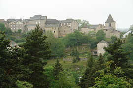 Gandrieu from across the valley | |
 Coat of arms | |
show Location of Grandrieu | |
 Grandrieu | |
| Coordinates: 44°47′07″N 3°38′02″E / 44.7853°N 3.6339°ECoordinates: 44°47′07″N 3°38′02″E / 44.7853°N 3.6339°E | |
| Country | France |
| Region | Occitanie |
| Department | Lozère |
| Arrondissement | Mende |
| Canton | Grandrieu |
| Intercommunality | CC Randon - Margeride |
| Government | |
| • Mayor (2020–2026) | Guy Galtier[1] |
| Area 1 | 65.37 km2 (25.24 sq mi) |
| Population (Jan. 2018)[2] | 752 |
| • Density | 12/km2 (30/sq mi) |
| Time zone | UTC+01:00 (CET) |
| • Summer (DST) | UTC+02:00 (CEST) |
| INSEE/Postal code | 48070 /48600 |
| Elevation | 867–1,317 m (2,844–4,321 ft) (avg. 1,160 m or 3,810 ft) |
| 1 French Land Register data, which excludes lakes, ponds, glaciers > 1 km2 (0.386 sq mi or 247 acres) and river estuaries. | |


Grandrieu (French pronunciation: [gʁɑ̃ʁjø]; Occitan: Grandriu) is a village and commune in the Lozère department in southern France.
Geography[]
The Chapeauroux forms parts of the commune's north-eastern border.
See also[]
References[]
- ^ "Répertoire national des élus: les maires". data.gouv.fr, Plateforme ouverte des données publiques françaises (in French). 2 December 2020. Retrieved 7 December 2020.
- ^ "Populations légales 2018". INSEE. 28 December 2020.
| Wikimedia Commons has media related to Grandrieu (Lozère). |
This Lozère geographical article is a stub. You can help Wikipedia by . |
Categories:
- Communes of Lozère
- Lozère geography stubs