Saint-Léger-de-Peyre
Saint-Léger-de-Peyre | |
|---|---|
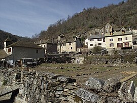 The village of St-Léger-de-Peyre in the Colagne valley, north of Marvejols | |
show Location of Saint-Léger-de-Peyre | |
 Saint-Léger-de-Peyre | |
| Coordinates: 44°35′43″N 3°18′07″E / 44.5953°N 3.3019°ECoordinates: 44°35′43″N 3°18′07″E / 44.5953°N 3.3019°E | |
| Country | France |
| Region | Occitanie |
| Department | Lozère |
| Arrondissement | Mende |
| Canton | Marvejols |
| Intercommunality | Gévaudan |
| Government | |
| • Mayor (2020–2026) | Jean-Paul Itier[1] |
| Area 1 | 27.35 km2 (10.56 sq mi) |
| Population (Jan. 2018)[2] | 189 |
| • Density | 6.9/km2 (18/sq mi) |
| Time zone | UTC+01:00 (CET) |
| • Summer (DST) | UTC+02:00 (CEST) |
| INSEE/Postal code | 48168 /48100 |
| Elevation | 670–1,154 m (2,198–3,786 ft) (avg. 720 m or 2,360 ft) |
| 1 French Land Register data, which excludes lakes, ponds, glaciers > 1 km2 (0.386 sq mi or 247 acres) and river estuaries. | |


Saint-Léger-de-Peyre (French pronunciation: [sɛ̃ leʒe də pɛʁ]; Occitan: Sent Latgièr de Peire) is a commune in the Lozère department in southern France.
Geography[]
The Colagne flows southwestward through the southern part of the commune and crosses the village.
See also[]
References[]
- ^ "Répertoire national des élus: les maires". data.gouv.fr, Plateforme ouverte des données publiques françaises (in French). 2 December 2020. Retrieved 7 December 2020.
- ^ "Populations légales 2018". INSEE. 28 December 2020.
| Wikimedia Commons has media related to Saint-Léger-de-Peyre. |
This Lozère geographical article is a stub. You can help Wikipedia by . |
Categories:
- Communes of Lozère
- Lozère geography stubs