Villefort, Lozère
Villefort | |
|---|---|
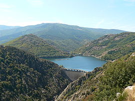 Dam and lake of Villefort | |
 Coat of arms | |
show Location of Villefort | |
 Villefort | |
| Coordinates: 44°26′25″N 3°55′58″E / 44.4403°N 3.9328°ECoordinates: 44°26′25″N 3°55′58″E / 44.4403°N 3.9328°E | |
| Country | France |
| Region | Occitanie |
| Department | Lozère |
| Arrondissement | Mende |
| Canton | Saint-Étienne-du-Valdonnez |
| Intercommunality | CC Mont Lozère |
| Government | |
| • Mayor (2020–2026) | Alain Lafont[1] |
| Area 1 | 7.35 km2 (2.84 sq mi) |
| Population (Jan. 2018)[2] | 546 |
| • Density | 74/km2 (190/sq mi) |
| Time zone | UTC+01:00 (CET) |
| • Summer (DST) | UTC+02:00 (CEST) |
| INSEE/Postal code | 48198 /48800 |
| Elevation | 509–960 m (1,670–3,150 ft) (avg. 605 m or 1,985 ft) |
| 1 French Land Register data, which excludes lakes, ponds, glaciers > 1 km2 (0.386 sq mi or 247 acres) and river estuaries. | |


Villefort is a commune in the Lozère department in southern France.
People[]
Villefort was the birthplace of Odilon Barrot (1791–1873), politician and Prime Minister of France.
See also[]
References[]
- ^ "Répertoire national des élus: les maires". data.gouv.fr, Plateforme ouverte des données publiques françaises (in French). 2 December 2020. Retrieved 7 December 2020.
- ^ "Populations légales 2018". INSEE. 28 December 2020.
External links[]
 Media related to Villefort, Lozère at Wikimedia Commons
- Regordane Info - The independent portal for The Regordane Way or St Gilles Trail, which passes through Villefort.
This Lozère geographical article is a stub. You can help Wikipedia by . |
Categories:
- Communes of Lozère
- Lozère geography stubs