Pourcharesses
Pourcharesses | |
|---|---|
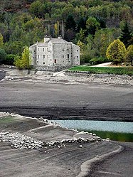 The Château de Castanet, in Pourcharesses | |
show Location of Pourcharesses | |
 Pourcharesses | |
| Coordinates: 44°28′21″N 3°55′07″E / 44.47250°N 3.9186°ECoordinates: 44°28′21″N 3°55′07″E / 44.47250°N 3.9186°E | |
| Country | France |
| Region | Occitanie |
| Department | Lozère |
| Arrondissement | Mende |
| Canton | Saint-Étienne-du-Valdonnez |
| Intercommunality | CC Mont Lozère |
| Government | |
| • Mayor (2020–2026) | René Causse[1] |
| Area 1 | 31.79 km2 (12.27 sq mi) |
| Population (Jan. 2018)[2] | 120 |
| • Density | 3.8/km2 (9.8/sq mi) |
| Time zone | UTC+01:00 (CET) |
| • Summer (DST) | UTC+02:00 (CEST) |
| INSEE/Postal code | 48117 /48800 |
| Elevation | 600–1,662 m (1,969–5,453 ft) (avg. 600 m or 2,000 ft) |
| 1 French Land Register data, which excludes lakes, ponds, glaciers > 1 km2 (0.386 sq mi or 247 acres) and river estuaries. | |


Pourcharesses (French pronunciation: [puʁʃaʁɛs]; Occitan: Porchareças) is a commune in the Lozère department in southern France.
See also[]
References[]
- ^ "Répertoire national des élus: les maires". data.gouv.fr, Plateforme ouverte des données publiques françaises (in French). 2 December 2020. Retrieved 7 December 2020.
- ^ "Populations légales 2018". INSEE. 28 December 2020.
External links[]
 Media related to Pourcharesses at Wikimedia Commons
This Lozère geographical article is a stub. You can help Wikipedia by . |
Categories:
- Communes of Lozère
- Lozère geography stubs