Chaudeyrac
Chaudeyrac | |
|---|---|
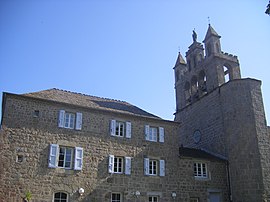 The bell tower in Chaudeyrac | |
show Location of Chaudeyrac | |
 Chaudeyrac | |
| Coordinates: 44°39′37″N 3°45′26″E / 44.6603°N 3.7572°ECoordinates: 44°39′37″N 3°45′26″E / 44.6603°N 3.7572°E | |
| Country | France |
| Region | Occitanie |
| Department | Lozère |
| Arrondissement | Mende |
| Canton | Grandrieu |
| Government | |
| • Mayor (2020–2026) | Serge Romieu[1] |
| Area 1 | 44.10 km2 (17.03 sq mi) |
| Population (Jan. 2018)[2] | 299 |
| • Density | 6.8/km2 (18/sq mi) |
| Time zone | UTC+01:00 (CET) |
| • Summer (DST) | UTC+02:00 (CEST) |
| INSEE/Postal code | 48045 /48170 |
| Elevation | 1,119–1,436 m (3,671–4,711 ft) (avg. 1,143 m or 3,750 ft) |
| 1 French Land Register data, which excludes lakes, ponds, glaciers > 1 km2 (0.386 sq mi or 247 acres) and river estuaries. | |


Chaudeyrac (French pronunciation: [ʃodeʁak]; Occitan: Chaudairac) is a commune in the Lozère department in southern France.
The small villages of Fouzillic and Fouzillac, 300 m from each other, are located on the territory of the commune. The villages are mentioned by Robert Louis Stevenson in Travels with a Donkey in the Cévennes. He was there on September 24–25, 1878, while on his way to Cheylard-l'Évêque. He refers to the villages as "Fouzilhic" and "Fouzilhac".[3][4]
See also[]
References[]
- ^ "Répertoire national des élus: les maires". data.gouv.fr, Plateforme ouverte des données publiques françaises (in French). 2 December 2020. Retrieved 7 December 2020.
- ^ "Populations légales 2018". INSEE. 28 December 2020.
- ^ Fouzillic et Fouzillac
- ^ Stevenson's text on Wikisource
| Wikimedia Commons has media related to Chaudeyrac. |
This Lozère geographical article is a stub. You can help Wikipedia by . |
Categories:
- Communes of Lozère
- Robert Louis Stevenson
- Lozère geography stubs