Berlare
Berlare | |
|---|---|
 | |
 Flag  Coat of arms | |
 Berlare Location in Belgium
show Location of Berlare in East Flanders | |
| Coordinates: 51°01′30″N 04°00′09″E / 51.02500°N 4.00250°ECoordinates: 51°01′30″N 04°00′09″E / 51.02500°N 4.00250°E | |
| Country | Belgium |
| Community | Flemish Community |
| Region | Flemish Region |
| Province | East Flanders |
| Arrondissement | Dendermonde |
| Government | |
| • Mayor | (Open VLD) |
| • Governing party/ies | Open VLD, sp.a |
| Area | |
| • Total | 37.82 km2 (14.60 sq mi) |
| Population (2018-01-01)[1] | |
| • Total | 14,849 |
| • Density | 390/km2 (1,000/sq mi) |
| Postal codes | 9290 |
| Area codes | 09, 052 |
| Website | www.berlare.be |


Berlare (Dutch pronunciation: [ˈbɛrlaːrə]) is a municipality located in the Belgian province of East Flanders. The municipality comprises the towns of Berlare proper, Overmere and , as well as the village . The Donkmeer, a large lake and a regional tourist attraction, is located centrally in the municipality. On January 1, 2012, Berlare had a total population of 14,690.
History[]
It was where the 1798 rebellion against French rule, known as the "Peasants' War" began in 1798.
Places of interest[]
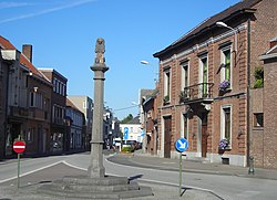
- The church of Saint Martin and a 17th-century pillory in the center of Berlare proper. The , also in the town center, was opened to the public in 2012.
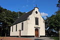
- The , built in the 14th century and expanded in 1774 in Rococo style, is situated in Donk. There is a Way of the Cross and calvary with sculptures by next to the chapel.
- The Donkmeer is a lake, about 86 ha in size, that came into existence through the harvesting of peat.
- Recreation area .
- Forested areas with trails include and the .
- is a very small museum about the historic river transport of manure from the city to the countryside.

Saint Martin's in Berlare
The in the village

The
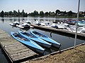
The Donkmeer is a regional tourist attraction


Famous inhabitants[]
- Tjörven De Brul, soccer player
- Fred De Bruyne, cyclist and TV commentator
- Karel De Gucht, politician
- Paul Cammermans, film director and actor
- Yves Van Der Straeten, soccer player
- Preben Van Hecke, cyclist
- , theater, opera, musical and TV director
- , cyclist
- Cecile Bombeek, serial killer
References[]
- ^ "Wettelijke Bevolking per gemeente op 1 januari 2018". Statbel. Retrieved 9 March 2019.
External links[]
 Media related to Berlare at Wikimedia Commons
- Official website (in Dutch)
| show Places adjacent to Berlare |
|---|

| show Authority control |
|---|
Categories:
- Berlare
- Municipalities of East Flanders