Aalter
This article needs additional citations for verification. (February 2013) |
Aalter | |
|---|---|
 | |
 Flag  Coat of arms | |
 Aalter Location in Belgium
show Location of Aalter in East Flanders | |
| Coordinates: 51°05′N 03°27′E / 51.083°N 3.450°ECoordinates: 51°05′N 03°27′E / 51.083°N 3.450°E | |
| Country | Belgium |
| Community | Flemish Community |
| Region | Flemish Region |
| Province | East Flanders |
| Arrondissement | Ghent |
| Government | |
| • Mayor | Pieter De Crem (CD&V) |
| • Governing party/ies | CD&V |
| Area | |
| • Total | 81.92 km2 (31.63 sq mi) |
| Postal codes | 9880 |
| Area codes | 09 |
| Website | www.aalter.be |


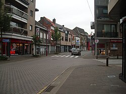
Aalter (Dutch pronunciation: [ˈaːltər]) is a municipality located between Bruges and Ghent in the Belgian province of East Flanders. The municipality comprises the towns of Aalter, Bellem, , Poeke, Knesselare and Ursel. It is bordered on the north by Maldegem, on the east by Zomergem and Nevele, on the south by Deinze, and on the west by the province of West Flanders. On January 1, 2007, Aalter had a total population of 18,887. The total area is 81.92 km2 which gives a population density of 231 inhabitants per km2. The mayor is Pieter De Crem.
Effective 1 January 2019, the municipality of Knesselare was merged into Aalter.
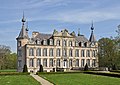
Gallery[]

Pigeon-tower in Bellem

Mariahove castle in Bellem


See also[]
References[]
External links[]
 Media related to Aalter at Wikimedia Commons
- Official website - Only available in Dutch
- Page about Aalter on rootsweb.com
| show Places adjacent to Aalter |
|---|

| show Authority control |
|---|
This East Flanders location article is a stub. You can help Wikipedia by . |
- Aalter
- Municipalities of East Flanders
- East Flanders geography stubs