Lokeren
This article needs additional citations for verification. (February 2015) |
Lokeren | |
|---|---|
 The Old Postoffice of Lokeren | |
 Flag  Coat of arms | |
 Lokeren Location in Belgium
show Location of Lokeren in East Flanders | |
| Coordinates: 51°06′N 03°59′E / 51.100°N 3.983°ECoordinates: 51°06′N 03°59′E / 51.100°N 3.983°E | |
| Country | Belgium |
| Community | Flemish Community |
| Region | Flemish Region |
| Province | East Flanders |
| Arrondissement | Sint-Niklaas |
| Government | |
| • Mayor | Filip Anthuenis ( Open-VLD) |
| • Governing party/ies | Open-VLD, SAMEN |
| Area | |
| • Total | 67.50 km2 (26.06 sq mi) |
| Population (2018-01-01)[1] | |
| • Total | 41,438 |
| • Density | 610/km2 (1,600/sq mi) |
| Postal codes | 9160 |
| Area codes | 09 |
| Website | www.lokeren.be |


Lokeren (Dutch pronunciation: [ˈloːkərə(n)]) is a municipality located in the Belgian province of East Flanders, and belongs to the Waasland, also called Land van Waas, of which it is the second most important city after Sint-Niklaas. The city, located on the river Durme, the Lede, and the E17 motorway, has more than 42,100 inhabitants, who are called Lokeraars or Rapenfretters. Because Lokeren is located on the Durme, Lokeren is often called "The Durme City". Horse sausages are officially recognized as a regional product.
Origins[]

Archaeological finds on the Lokeren territory prove that this area was populated in Neolithic times. A Roman road ran along the Durme river. The name Waas was given to this area by the Romans from the Germanic root Wasu meaning "marshy land". The first mention of the name Lokeren, however, dates from 1114. Unlike the older settlements, the new village came to be built on the right bank of the Durme. By the middle of the 12th century, it had become an independent parish, with agriculture and flax as the two main drivers of the economy. The textile industry would remain important until well into the 20th century.
16th century until now[]
In 1555, Charles V gave Lokeren the right to hold a market. In the 16th and 17th century, the whole Waasland was in the line of fire between Protestant Netherlands and Catholic Spain, often with terrible consequences for the local population. After the French Revolution, the area was made part of the new Département de l'Escaut, with Lokeren at the head of a canton. This did not last long as the department was split in 1800 and Lokeren made part of the arrondissement of Dendermonde. Napoleon Bonaparte promoted the town to the status of city in 1804.
Until the 1970s, haircutting (an industrial practice of cutting hair from rabbit skins to make felt, a basic material for hat makers) and slaughterhouses were among Lokeren's main industries. Today, the city enjoys a more varied economical and cultural infra-structure.
Sights[]
- Lokeren counts a number of art galleries and a museum, which covers local history from prehistoric archaeology to the mid-20th century.
- , built in 1725.
- Since 10 June 1956, the city has been endowed with a 49-bell carillon.
- The nature preservation area is on Lokeren's territory.
- The façade of the Sint-Lodewijks college, High-School.

The Durme river
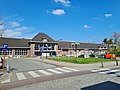
Lokeren Station
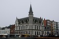
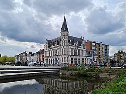
The Old Post Office
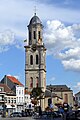
Church of Saint Laurence

Daknam, East Flanders


Notable inhabitants[]
- Frans Rens, writer (1805–1874)
- Miet Smet, politician (b. 1943)
- Aimé Anthuenis, former football player and coach (b. 1943)
- Gabriel of Comane, archbishop of Western Europe of the Ecumenical Patriarchate of the Eastern Orthodox church (b. 1946)
- Marleen Temmerman, gynaecologist (b. 1953)
- François Van Der Elst, former international football player (b. 1954)
- Paul Verhaeghen, novelist (b. 1965)
- Jelle Van Damme, football player (b. 1983)
- Tim Coppens, fashion designer
- , actor and imitator (b. 1960)
Sports and events[]

- The best football club of the city is K.S.C. Lokeren Oost-Vlaanderen.
- Lokeren is well known within Flanders for an annual ten-day music fest and fair (the Lokerse Feesten), which takes place during the first week of August.
On 14 July 1970, Lokeren was the scene of a sporting disaster, when a minibus carrying a team of speedway riders from West Ham, London, was involved in a collision with a petrol tanker. 4 riders were killed, two seriously injured and Phil Bishop a famous speedway ace from the 1930s, who was managing the team was also killed.[3]
References[]
- ^ "Wettelijke Bevolking per gemeente op 1 januari 2018". Statbel. Retrieved 9 March 2019.
- ^ "Kroniek van Lokeren". lib.ugent.be. Retrieved 27 August 2020.
- ^ "Tragic West Ham speedway crash remembered on 46th anniversary".
External links[]
![]() Media related to Lokeren at Wikimedia Commons
Media related to Lokeren at Wikimedia Commons
- Official website (in Dutch)
- Sporting Lokeren – Information about K.S.C Lokeren Oost-Vlaanderen
- Lokerse Feesten – Information about the annual Lokeren music festival "Lokerse Feesten"
- Lokeren in beeld – Views of Lokeren
- . Encyclopædia Britannica (11th ed.). 1911.
| show Places adjacent to Lokeren |
|---|

| show Authority control |
|---|
- Lokeren
- Municipalities of East Flanders
- Waasland