Blatnička
Blatnička | |
|---|---|
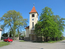 Church of the Assumption of the Virgin Mary | |
 Flag  Coat of arms | |
 Blatnička Location in the Czech Republic | |
| Coordinates: 48°56′8″N 17°31′48″E / 48.93556°N 17.53000°ECoordinates: 48°56′8″N 17°31′48″E / 48.93556°N 17.53000°E | |
| Country | |
| Region | South Moravian |
| District | Hodonín |
| First mentioned | 1362 |
| Area | |
| • Total | 8.82 km2 (3.41 sq mi) |
| Elevation | 263 m (863 ft) |
| Population (2020-01-01[1]) | |
| • Total | 424 |
| • Density | 48/km2 (120/sq mi) |
| Time zone | UTC+1 (CET) |
| • Summer (DST) | UTC+2 (CEST) |
| Postal code | 696 71 |
| Website | www |

Blatnička is a municipality and village in Hodonín District in the South Moravian Region of the Czech Republic. It has about 400 inhabitants.
Twin towns – sister cities[]
 Falkenstein, Austria
References[]
- ^ "Population of Municipalities – 1 January 2020". Czech Statistical Office. 2020-04-30.
- ^ "Portál CZ". obecblatnicka.cz (in Czech). Obec Blatnička. Retrieved 2021-04-19.
| Wikimedia Commons has media related to Blatnička. |
| Authority control: National libraries |
|---|
This South Moravian Region location article is a stub. You can help Wikipedia by . |
Categories:
- Villages in Hodonín District
- Moravian Slovakia
- South Moravian Region geography stubs