Boran-sur-Oise
Boran-sur-Oise | |
|---|---|
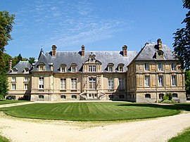 The chateau in Boran-sur-Oise | |
 Coat of arms | |
show Location of Boran-sur-Oise | |
 Boran-sur-Oise | |
| Coordinates: 49°10′00″N 2°21′34″E / 49.1667°N 2.3594°ECoordinates: 49°10′00″N 2°21′34″E / 49.1667°N 2.3594°E | |
| Country | France |
| Region | Hauts-de-France |
| Department | Oise |
| Arrondissement | Senlis |
| Canton | Chantilly |
| Government | |
| • Mayor (2020–2026) | Jean-Jacques Dumortier[1] |
| Area 1 | 11.25 km2 (4.34 sq mi) |
| Population (Jan. 2018)[2] | 2,156 |
| • Density | 190/km2 (500/sq mi) |
| Time zone | UTC+01:00 (CET) |
| • Summer (DST) | UTC+02:00 (CEST) |
| INSEE/Postal code | 60086 /60820 |
| Elevation | 24–103 m (79–338 ft) |
| 1 French Land Register data, which excludes lakes, ponds, glaciers > 1 km2 (0.386 sq mi or 247 acres) and river estuaries. | |


Boran-sur-Oise (French pronunciation: [bɔʁɑ̃ syʁ waz], literally Boran on Oise) is a commune in the Oise department in northern France.
Population[]
|
|
See also[]
References[]
- ^ "Répertoire national des élus: les maires". data.gouv.fr, Plateforme ouverte des données publiques françaises (in French). 2 December 2020.
- ^ "Populations légales 2018". INSEE. 28 December 2020.
| Wikimedia Commons has media related to Boran-sur-Oise. |
| show Authority control |
|---|
This Oise geographical article is a stub. You can help Wikipedia by . |
Categories:
- Communes of Oise
- Oise geography stubs