Boulay-Moselle
Boulay-Moselle | |
|---|---|
Subprefecture and commune | |
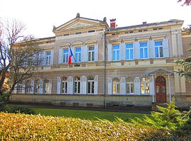 The subprefecture in Boulay-Moselle | |
 Coat of arms | |
show Location of Boulay-Moselle | |
 Boulay-Moselle | |
| Coordinates: 49°11′03″N 6°29′39″E / 49.1842°N 6.4942°ECoordinates: 49°11′03″N 6°29′39″E / 49.1842°N 6.4942°E | |
| Country | France |
| Region | Grand Est |
| Department | Moselle |
| Arrondissement | Forbach-Boulay-Moselle |
| Canton | Boulay-Moselle |
| Intercommunality | Houve-Pays Boulageois |
| Government | |
| • Mayor (2020–2026) | André Boucher |
| Area 1 | 19.55 km2 (7.55 sq mi) |
| Population (Jan. 2018)[1] | 5,591 |
| • Density | 290/km2 (740/sq mi) |
| Time zone | UTC+01:00 (CET) |
| • Summer (DST) | UTC+02:00 (CEST) |
| INSEE/Postal code | 570097 /57220 |
| 1 French Land Register data, which excludes lakes, ponds, glaciers > 1 km2 (0.386 sq mi or 247 acres) and river estuaries. | |


Boulay-Moselle (French pronunciation: [bulɛ mɔzel]; German: Bolchen, Moselle Franconian: Bolchin) is a commune in the Moselle department in Grand Est in northeastern France. The locality of Halling-lès-Boulay (German: Hallingen) was incorporated in the commune in 1972.
Population[]
|
|
See also[]
References[]
- ^ "Populations légales 2018". INSEE. 28 December 2020.
| Wikimedia Commons has media related to Boulay-Moselle. |
| show Authority control |
|---|
Categories:
- Communes of Moselle (department)
- Forbach-Boulay-Moselle arrondissement geography stubs