Bousseviller
Bousseviller | |
|---|---|
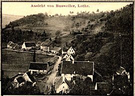 A postcard view of Bousseviller in 1912 | |
 Coat of arms | |
show Location of Bousseviller | |
 Bousseviller | |
| Coordinates: 49°07′18″N 7°27′54″E / 49.1217°N 7.465°ECoordinates: 49°07′18″N 7°27′54″E / 49.1217°N 7.465°E | |
| Country | France |
| Region | Grand Est |
| Department | Moselle |
| Arrondissement | Sarreguemines |
| Canton | Bitche |
| Intercommunality | CC du Pays de Bitche |
| Government | |
| • Mayor (2020–2026) | Maryline Mérel[1] |
| Area 1 | 4.01 km2 (1.55 sq mi) |
| Population (Jan. 2018)[2] | 125 |
| • Density | 31/km2 (81/sq mi) |
| Time zone | UTC+01:00 (CET) |
| • Summer (DST) | UTC+02:00 (CEST) |
| INSEE/Postal code | 57103 /57230 |
| Elevation | 257–384 m (843–1,260 ft) (avg. 150 m or 490 ft) |
| 1 French Land Register data, which excludes lakes, ponds, glaciers > 1 km2 (0.386 sq mi or 247 acres) and river estuaries. | |


Bousseviller (German: Busweiler, Lorraine Franconian: Busswiller) is a commune in the Moselle department of the Grand Est administrative region in north-eastern France.
The village belongs to the Pays de Bitche and to the Northern Vosges Regional Nature Park.
Population[]
|
|
See also[]
| Wikimedia Commons has media related to Bousseviller. |
References[]
- ^ "Répertoire national des élus: les maires". data.gouv.fr, Plateforme ouverte des données publiques françaises (in French). 2 December 2020.
- ^ "Populations légales 2018". INSEE. 28 December 2020.

| show Authority control |
|---|
Categories:
- Communes of Moselle (department)
- Sarreguemines arrondissement geography stubs