Breuil-le-Sec
Breuil-le-Sec | |
|---|---|
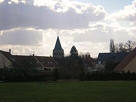 A general view of Breuil-le-Sec | |
 Coat of arms | |
show Location of Breuil-le-Sec | |
 Breuil-le-Sec | |
| Coordinates: 49°22′15″N 2°27′11″E / 49.3708°N 2.4531°ECoordinates: 49°22′15″N 2°27′11″E / 49.3708°N 2.4531°E | |
| Country | France |
| Region | Hauts-de-France |
| Department | Oise |
| Arrondissement | Clermont |
| Canton | Clermont |
| Intercommunality | Clermontois |
| Government | |
| • Mayor (2020–2026) | Denis Dupuis |
| Area 1 | 8.89 km2 (3.43 sq mi) |
| Population (Jan. 2018)[1] | 2,663 |
| • Density | 300/km2 (780/sq mi) |
| Time zone | UTC+01:00 (CET) |
| • Summer (DST) | UTC+02:00 (CEST) |
| INSEE/Postal code | 60106 /60840 |
| Elevation | 46–152 m (151–499 ft) (avg. 61 m or 200 ft) |
| 1 French Land Register data, which excludes lakes, ponds, glaciers > 1 km2 (0.386 sq mi or 247 acres) and river estuaries. | |


Breuil-le-Sec (French pronunciation: [bʁœj lə sɛk]) is a commune in the Oise department in northern France.
Population[]
| Year | Pop. | ±% |
|---|---|---|
| 1793 | 620 | — |
| 1800 | 595 | −4.0% |
| 1806 | 588 | −1.2% |
| 1821 | 572 | −2.7% |
| 1831 | 599 | +4.7% |
| 1836 | 566 | −5.5% |
| 1841 | 532 | −6.0% |
| 1846 | 506 | −4.9% |
| 1851 | 478 | −5.5% |
| 1856 | 502 | +5.0% |
| 1861 | 507 | +1.0% |
| 1866 | 510 | +0.6% |
| 1872 | 503 | −1.4% |
| 1876 | 471 | −6.4% |
| 1881 | 457 | −3.0% |
| 1886 | 443 | −3.1% |
| 1891 | 425 | −4.1% |
| 1896 | 443 | +4.2% |
| 1901 | 490 | +10.6% |
| 1906 | 436 | −11.0% |
| 1911 | 480 | +10.1% |
| 1921 | 480 | +0.0% |
| 1926 | 492 | +2.5% |
| 1931 | 540 | +9.8% |
| 1936 | 588 | +8.9% |
| 1946 | 636 | +8.2% |
| 1954 | 1,390 | +118.6% |
| 1962 | 2,168 | +56.0% |
| 1968 | 2,200 | +1.5% |
| 1975 | 2,321 | +5.5% |
| 1982 | 2,421 | +4.3% |
| 1990 | 2,416 | −0.2% |
| 1999 | 2,058 | −14.8% |
| 2006 | 2,303 | +11.9% |
| 2009 | 2,364 | +2.6% |
| 2012 | 2,463 | +4.2% |
See also[]
References[]
- ^ "Populations légales 2018". INSEE. 28 December 2020.
| Wikimedia Commons has media related to Breuil-le-Sec. |
This Oise geographical article is a stub. You can help Wikipedia by . |
Categories:
- Communes of Oise
- Oise geography stubs