Briollay
Briollay | |
|---|---|
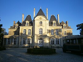 The Chateau de Norieux | |
show Location of Briollay | |
 Briollay | |
| Coordinates: 47°33′54″N 0°30′26″W / 47.565°N 0.5072°WCoordinates: 47°33′54″N 0°30′26″W / 47.565°N 0.5072°W | |
| Country | France |
| Region | Pays de la Loire |
| Department | Maine-et-Loire |
| Arrondissement | Angers |
| Canton | Angers-5 |
| Intercommunality | CU Angers Loire Métropole |
| Government | |
| • Mayor (2020–2026) | Arnaud Hie[1] |
| Area 1 | 15.06 km2 (5.81 sq mi) |
| Population (Jan. 2018)[2] | 3,036 |
| • Density | 200/km2 (520/sq mi) |
| Time zone | UTC+01:00 (CET) |
| • Summer (DST) | UTC+02:00 (CEST) |
| INSEE/Postal code | 49048 /49125 |
| Elevation | 13–64 m (43–210 ft) |
| 1 French Land Register data, which excludes lakes, ponds, glaciers > 1 km2 (0.386 sq mi or 247 acres) and river estuaries. | |


Briollay (French pronunciation: [bʁijɔlɛ]) is a commune in the Maine-et-Loire department in western France.
Population[]
|
|
Sights[]
See also[]
- Communes of the Maine-et-Loire department
References[]
- ^ "Répertoire national des élus: les maires". data.gouv.fr, Plateforme ouverte des données publiques françaises (in French). 2 December 2020.
- ^ "Populations légales 2018". INSEE. 28 December 2020.
External links[]
| Wikimedia Commons has media related to Briollay. |
| show Authority control |
|---|
This Maine-et-Loire geographical article is a stub. You can help Wikipedia by . |
Categories:
- Communes of Maine-et-Loire
- Maine-et-Loire geography stubs