Orée-d'Anjou
Orée-d'Anjou | |
|---|---|
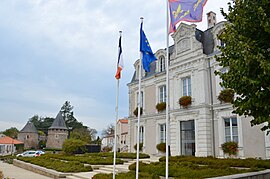 The town hall of Champtoceaux with the towers of the château in the background | |
Location of Orée-d'Anjou  | |
 Orée-d'Anjou | |
| Coordinates: 47°20′13″N 1°15′50″W / 47.337°N 1.264°WCoordinates: 47°20′13″N 1°15′50″W / 47.337°N 1.264°W | |
| Country | France |
| Region | Pays de la Loire |
| Department | Maine-et-Loire |
| Arrondissement | Cholet |
| Canton | Mauges-sur-Loire |
| Intercommunality | Mauges Communauté |
| Government | |
| • Mayor (2020–2026) | Aline Bray[1] |
| Area 1 | 156.34 km2 (60.36 sq mi) |
| Population (Jan. 2018)[2] | 16,354 |
| • Density | 100/km2 (270/sq mi) |
| Time zone | UTC+01:00 (CET) |
| • Summer (DST) | UTC+02:00 (CEST) |
| INSEE/Postal code | 49069 /49270, 49530 |
| 1 French Land Register data, which excludes lakes, ponds, glaciers > 1 km2 (0.386 sq mi or 247 acres) and river estuaries. | |


Orée-d'Anjou is a commune in the Maine-et-Loire department of western France. Champtoceaux is the municipal seat.
History[]
It was established on 15 December 2015 and consists of the former communes of Bouzillé, Champtoceaux, Drain, Landemont, Liré, Saint-Christophe-la-Couperie, Saint-Laurent-des-Autels, Saint-Sauveur-de-Landemont and La Varenne.[3]
See also[]
- Communes of the Maine-et-Loire department
References[]
| Wikimedia Commons has media related to Orée d'Anjou. |
- ^ Orée-d’Anjou. Municipales 2020 : Aline Bray élue avec 52,90 %, Ouest-France, 16 March 2020 (in French)
- ^ "Populations légales 2018". The National Institute of Statistics and Economic Studies. 28 December 2020.
- ^ Arrêté préfectoral, 25 November 2015 (in French)
This Maine-et-Loire geographical article is a stub. You can help Wikipedia by . |
Categories:
- Communes of Maine-et-Loire
- States and territories established in 2015
- Maine-et-Loire geography stubs