Segré-en-Anjou Bleu
Segré-en-Anjou Bleu | |
|---|---|
Subprefecture and commune | |
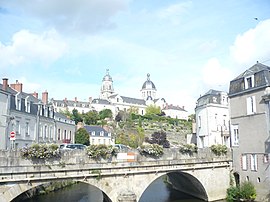 The church in Segré | |
show Location of Segré-en-Anjou Bleu | |
 Segré-en-Anjou Bleu | |
| Coordinates: 47°41′13″N 0°52′16″W / 47.687°N 0.871°WCoordinates: 47°41′13″N 0°52′16″W / 47.687°N 0.871°W | |
| Country | France |
| Region | Pays de la Loire |
| Department | Maine-et-Loire |
| Arrondissement | Segré |
| Canton | Segré-en-Anjou Bleu |
| Intercommunality | |
| Government | |
| • Mayor (2020–2026) | Geneviève Coquereau |
| Area 1 | 241.53 km2 (93.26 sq mi) |
| Population (Jan. 2018)[1] | 17,474 |
| • Density | 72/km2 (190/sq mi) |
| Time zone | UTC+01:00 (CET) |
| • Summer (DST) | UTC+02:00 (CEST) |
| INSEE/Postal code | 49331 /49500, 49520 |
| 1 French Land Register data, which excludes lakes, ponds, glaciers > 1 km2 (0.386 sq mi or 247 acres) and river estuaries. | |


Segré-en-Anjou Bleu (French pronunciation: [səɡʁe ɑ̃.n‿ɑ̃ʒu blø] (![]() listen), literally Segré in Blue Anjou) is a commune in the Maine-et-Loire department of western France. The municipality was established on 15 December 2016 and consists of the former communes of Aviré, Le Bourg-d'Iré, La Chapelle-sur-Oudon, Châtelais, La Ferrière-de-Flée, L'Hôtellerie-de-Flée, Louvaines, Marans, Montguillon, Noyant-la-Gravoyère, Nyoiseau, Sainte-Gemmes-d'Andigné, Saint-Martin-du-Bois, Saint-Sauveur-de-Flée and Segré.[2] It is a subprefecture of the Maine-et-Loire department.
listen), literally Segré in Blue Anjou) is a commune in the Maine-et-Loire department of western France. The municipality was established on 15 December 2016 and consists of the former communes of Aviré, Le Bourg-d'Iré, La Chapelle-sur-Oudon, Châtelais, La Ferrière-de-Flée, L'Hôtellerie-de-Flée, Louvaines, Marans, Montguillon, Noyant-la-Gravoyère, Nyoiseau, Sainte-Gemmes-d'Andigné, Saint-Martin-du-Bois, Saint-Sauveur-de-Flée and Segré.[2] It is a subprefecture of the Maine-et-Loire department.
See also[]
- Communes of the Maine-et-Loire department
References[]
| Wikimedia Commons has media related to Segré-en-Anjou Bleu. |
- ^ "Populations légales 2018". INSEE. 28 December 2020.
- ^ Arrêté préfectoral 28 September 2016 (in French)
| show Communes of the Maine-et-Loire department |
|---|
| Authority control |
|
|---|
This Maine-et-Loire geographical article is a stub. You can help Wikipedia by . |
Categories:
- Communes of Maine-et-Loire
- Subprefectures in France
- Anjou
- Maine-et-Loire geography stubs