CBD and South East Light Rail
| CBD and South East Light Rail | ||
|---|---|---|
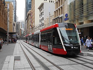 Citadis 305 on George Street in December 2019 | ||
| Overview | ||
| Owner | Transport for NSW | |
| Termini | Circular Quay Juniors Kingsford, Randwick | |
| Stations | 19 | |
| Service | ||
| Services | 2 | |
| Operator(s) | Transdev Sydney | |
| Depot(s) | Randwick | |
| Rolling stock | 60 Alstom Citadis 305s | |
| Daily ridership | 43,000 (January 2020)[1] | |
| History | ||
| Opened | 14 December 2019 (L2 Randwick) 3 April 2020 (L3 Kingsford) | |
| Technical | ||
| Track length | 12 km (7.5 mi) | |
| Track gauge | 1,435 mm (4 ft 8+1⁄2 in) standard gauge | |
| Electrification | 750 V (DC) overhead line Ground-level power supply between Town Hall and Circular Quay | |
| Operating speed | 70 km/h (43 mph) | |
| Signalling | Bombardier CTYFLO 250 LRT with on-board ATP[2] | |
| ||
The CBD and South East Light Rail is a light rail line in Sydney, New South Wales, Australia. Construction commenced in October 2015, with services between Circular Quay and Randwick commencing on 14 December 2019 as the L2 Randwick Line, and between Circular Quay and Kingsford on 3 April 2020 as the L3 Kingsford Line. It is part of Sydney's light rail network.
Background and initial announcement[]
Since the light rail network's original line opened in 1997, a line through the Sydney central business district had been suggested numerous times but failed to achieve State Government support.[3][4] This changed in February 2010 when the Keneally Government announced a new line from Haymarket to Circular Quay via Barangaroo.[5] The final route was not decided, with the three options being to send the line north via George Street, Sussex Street or a loop using both.[6]
When the O'Farrell Government took office in March 2011, it committed to building a line through the CBD to Barangaroo, with a preferred route along George Street.[7][8][9] It also committed to conducting feasibility studies into the construction of lines from the City to Sydney University and the City to the University of New South Wales.[8][10] On 8 December 2011, the government announced shortlisted potential routes for these extensions.[9] In 2012, Transport for NSW (TfNSW) decided the routes to Sydney University and Barangaroo via The Rocks provided fewer customer benefits and were considered a lower priority. A route from Circular Quay to the University of New South Wales via Central station was seen as the best option.[11]
On 13 December 2012, the government announced a commitment to build a $1.6 billion line from Circular Quay down George Street to Central station, then across to Moore Park and down Anzac Parade with branches to Kingsford and Randwick.[12] Construction was expected to begin in 2014 and to take five to six years.[12][13]
Design[]

The line services areas that were previously served by Sydney's former tram network. Some of the new route follows tram lines of the former network.
The route is mostly on-street but includes an off-street section through Moore Park. The only major engineering works on the line were a new bridge over the Eastern Distributor and a tunnel under Moore Park and Anzac Parade. There will be between eight and ten new traffic light controlled intersections created along the route.[citation needed]
Several changes to the design were announced in December 2014. The major changes involve revising platform lengths at all stops to support an increase in the length of the trams from 45 metres to 67 metres, redesigning several stops, switching technologies for the delivery of the wire-free section and the removal of a proposed stop at World Square. It was also announced that the projected cost had increased from $1.6 billion to $2.2 billion. The government claimed the increase was due to the design modifications, but a 2016 report produced by the Audit Office of New South Wales found that the increase was largely due to TfNSW underestimating the cost of the project.[14][15][16]
A pedestrian zone was established along approximately 40% of George Street, between Bathurst and Hunter Streets.[12][17][18] The pedestrian zone is being extended southwards to Rawson Place in Haymarket as of March 2021 (see Post-opening works).
The section between Town Hall and Circular Quay is wire-free, with trams using Alstom's proprietary APS technology to run instead.[19] This was originally to have been achieved by equipping the trams with batteries and providing recharging facilities at stops.
The line is designed to handle special events in the Moore Park precinct and at Randwick Racecourse. Events at Moore Park were initially planned to be served using two coupled trams 90 metres (300 ft) long, with double length platforms at the Central Station and Moore Park stops.[17][18] Following the decision to make all tram vehicles operate in coupled pairs with a total length of 67 metres (220 ft), the plans to build double length platforms at Central and Moore Park were abandoned, and platforms of all stops were built to be 67 metres (220 ft) long.
A depot for the trams was built at the north-western corner of Randwick Racecourse, providing stabling facilities and allowing light maintenance. Heavy maintenance is conducted at the Lilyfield Maintenance Depot at the site of the former Rozelle Yard.[20] The maintenance depot will be accessed via the Inner West Light Rail.[17]
Construction[]

The line was built as a public-private partnership (PPP), with the contract covering detailed design, major construction, operation and maintenance of the line as well as the provision of rolling stock. A contract for early construction works was awarded to Laing O'Rourke in July 2014.[21]
In February 2014, three consortia were short listed for the main contract – covering the construction and operation of the line:[22][23]
- Connecting Sydney – Acciona Infrastructure Australia, Alstom, Capella Capital & Transdev
- iLinQ – Balfour Beatty, Bombardier Transportation, Keolis Downer, Macquarie Capital & McConnell Dowell
- SydneyConnect – John Holland, Plenary Group & Serco
The iLinQ consortium withdrew after Balfour Beatty pulled out. Balfour Beatty was reportedly concerned about cost overruns for the project and falling profitability of the company as a whole.[24]
On 23 October 2014, Connecting Sydney was announced as the preferred bidder. The contract was finalised in December 2014, when it was also announced that the consortium had been renamed ALTRAC Light Rail, and that the opening date had been brought forward to early 2019.[25] The contract also included the operation and maintenance of the Inner West Light Rail from mid-2015.[26][27][28]
Major construction commenced on 23 October 2015, beginning in the section of George Street between King and Market Streets. To minimise disruption along the length of the corridor, works were staggered across 31 construction zones. The first section of track in the CBD was laid in December 2016, by which time a total of 410 metres of track had already been laid across the project.[29] This increased to around 5 kilometres of track by May 2017.[30] By October 2017, track installation reached the halfway mark, with 12,000 metres of track laid at 23 of the 31 zones along the alignment.[31]
Bus Network Changes[]

The CBD and South East Light Rail required significant changes to the bus networks of the Sydney central business district and the Eastern Suburbs. Prior to construction of the light rail, Hillsbus and State Transit bus routes using George Street were permanently removed from the street. The network will be further redesigned when the light rail opens in 2020. Some bus routes from the Eastern Suburbs will be removed from the CBD, with many of the routes integrated with the light rail interchanges at Randwick and Kingsford. Some passengers will be required to change from bus to light rail to complete their journey.
To accommodate construction of the light rail on George Street, new bus timetables were introduced on 4 October 2015. Buses were diverted from George Street on to other streets in the CBD, including Elizabeth, Castlereagh, Park, Druitt, Clarence and York Streets.[32] Some routes had their terminus changed to such places as Railway Square, Queen Victoria Building and King Street Wharf. A small number of routes were either combined so that they run through the CBD without terminating, removed from the CBD entirely or completely discontinued.[33][34][35][36][37]
Delays[]
Construction suffered from significant delays. Major construction of the project was due to conclude in April 2018, though finishing works were to continue for some time after.[32][38]
Delays at two zones in the CBD were announced in August 2016. Originally meant to be completed before Christmas 2016, construction work at these zones was to continue for several months longer than originally anticipated.[39] The zones were eventually opened around a year after the planned completion date.[40] Further delays to the project arose during 2016.[41]
By the beginning of 2018 the whole project was significantly behind schedule. In March 2018 – one month before major works were originally due to be completed – the Transport Minister declined to put a date on when he expected construction of the line to be finished, but noted the government was "an unhappy customer" of the ALTRAC consortium.[42]
The relationship between the New South Wales Government and Acciona Infrastructure – the construction company delivering the line – had deteriorated with a dispute arising between the parties over costs incurred from modifications to the line's design.[41] Acciona commenced legal action against the government in April 2018. The company is seeking additional payments totalling $1.2 billion.[43] Later in the month ALTRAC told the government it was working towards a completion date of March 2020.[44][45]
In October 2018, Acciona announced further delays to the project, stating that it would not be completed until May 2020.[46]
In June 2019, TfNSW and ALTRAC (including Acciona) reached an agreement to resolve their commercial issues and legal claims. As part of the agreement, the PPP was extended to 2036, with the government to pay up to $576 million over the duration of an extended PPP term, and ALTRAC shareholders to invest additional equity into the project to meet costs.[47] The settlement package resolved over $1.5 billion of legal claims between TfNSW and ALTRAC, and Acciona withdrew its $1.1 billion legal misrepresentation claim against the government. The agreement also included milestone and incentive payments for light rail services to commence in two stages, with target start dates of December 2019 between Randwick and Circular Quay, and March 2020 between Kingsford and Circular Quay.
Associated works[]
Separate to the light rail budget, Randwick City Council earmarked $68 million to partially mitigate the impacts of the light rail. Projects include replacing some of the car parking spaces that were lost, especially in Kingsford, works to improve traffic flow in the district and public domain works.[48]
The City of Sydney planned to provide $220 million towards the light rail project. This would include money for public domain works on George Street and surrounding laneways.[49] The centrepiece of these works was to be a large arch structure known as Cloud Arch located outside the Sydney Town Hall, however it was cancelled in late 2018 after cost blowouts.[50] Cloud Arch would have acted as a gateway to the pedestrian section of George Street, with trams passing underneath it.[51]
Testing[]
In February 2018, testing of the line commenced on a short section of the Randwick branch along Alison Road.[52] Testing along the rest of the Randwick branch and the main line to Circular Quay was achieved in August 2019,[53] while the Kingsford branch, which will open three months later than the rest of the line, commenced testing in October 2019.[54]
Criticism[]
There have been criticism of the project from some parties:
- Action for Public Transport, that it will not have sufficient capacity to replace the bus routes eliminated[55]
- Save Our Suburbs, that it will disrupt vehicular traffic[56]
- Save Randwick's Trees objecting to the loss of nearly 1,000 trees including from Centennial, Moore and High Cross parks[57]
- Save our Park campaigning against the loss of Centennial, Moore and adjacent park lands[58]
Opening[]

The first L2 passenger service between Circular Quay and Randwick commenced just after 10:00 on 14 December 2019.[59][60][61] The opening weekend (14 and 15 December 2019) was fare-free, and 115,000 people used the new tram service during the opening weekend. The launch of the service on 14 December was interrupted by a tram which broke down at Circular Quay around 14:30 in the afternoon, within hours of the official opening ceremony.[62] Services were restored by 15:30.
L3 passenger services between Circular Quay and Juniors Kingsford commenced operations on 3 April 2020, opening quietly amidst the prioritisation of government aid for the ongoing coronavirus pandemic during the period.[63][64] Prior to the opening of the L3 line, additional L2 services ran between Circular Quay and Central Chalmers Street to provide the eventual frequency of light rail services in the CBD. With the opening of the Kingsford branch, services were extended beyond Central Chalmers Street towards Juniors Kingsford as L3 services.
Bus Network Changes[]
Proposed arrangement[]
The project's Environmental Impact Statement (EIS) released in 2013 proposed a redesigned bus network in the CBD and the Eastern Suburbs. Some bus routes which were diverted from George Street to other streets during the construction, were proposed to terminate at Railway Square with their passengers to join the Light Rail while others will be rerouted permanently to the streets to which they were diverted.[65] Twenty bus routes were proposed to be withdrawn or curtailed between Kingsford/Randwick and Railway Square/Circular Quay. A number of bus routes using Anzac Parade would unload city bound passengers at the Nine Ways (now Juniors Kingsford) interchange to board the light rail, then continue along Anzac Parade to the University of New South Wales to unload passengers before terminating in Todman Avenue, Kensington. Some bus routes that are currently operating to the city via Randwick would become feeder services that drop off city bound passengers at the light rail terminus.
The proposed changes for the Eastern Suburbs bus routes as per the EIS were as follows:[65]
| showProposed Eastern Suburbs bus route changes |
|---|
Some bus changes have been made to bus routes in the list, since 2013.
- Route 343 currently runs as a through route between Kingsford and Chatswood no longer terminating at the CBD.
- University of NSW routes were reconfigured as bus routes 891, 893 and 898. These, together with school route 610, ceased after 18 December 2020. [66]
- Routes M10 and M50 ceased 25 October 2020.[67]
Final arrangement[]
The final bus network was to be announced in due time and changes to bus services implemented four to six weeks after the commencement of L3 Kingsford Line services in April 2020.[68] However, as of March 2021, no such announcement has been made.
Post-opening works[]
Following the completion of light rail, the southbound lane of George Street from Bathurst Street to Campbell Street was never reopened to traffic.[69] In May 2020, City of Sydney proposed to convert the southern section of George Street (Bathurst Street to Rawson Place) to a pedestrian-only boulevard, extending the existing boulevard southwards from Bathurst Street.[70] These also included the narrowing of George Street to one lane per direction south of Rawson Place. The section of Devonshire Street between Chalmers Street and Elizabeth Street, which was also never reopened to traffic, was also proposed to be converted to a pedestrian boulevard. In July 2020, the northbound lane from Ultimo Street to Bathurst Street and the southbound lane from Campbell Street to Rawson Place was temporarily closed to traffic in preparation for a conversion in the future.[69]
Community consultation was undertaken between September and October 2020.[71] The proposed conversions of George Street and Devonshire Street were approved in the Council meeting in December 2020.[72] Works on George Street began on the east side of the light rail tracks near Bathurst Street in March 2021, and would progress south on both sides towards Railway Square, with works south of Goulburn Street to begin in late 2021[73] Works on Devonshire Street would begin in 2022.
Separate to the pedestrian boulevard works, the traffic lights at the intersection of Devonshire Street and Marlborough Street east of the Surry Hills stop were removed in February 2021. Right turn bans were also introduced from Devonshire Street to Crown Street in both directions. These were in response to a number of high risk safety incidents and complaints for long waiting times for pedestrians, trams, buses and motor vehicles.[74]
Operation[]


As a member of the ALTRAC Light Rail consortium, Transdev will operate the line until the end of the PPP, set to end at 2036.[47][75] Services on the Randwick branch are numbered L2 and services on the Kingsford branch are numbered L3.[76]
Fleet[]
The service is operated by 60 five-section Alstom Citadis 305 trams operating in coupled pairs.[77][78] The first was completed in May 2017, arriving at the Randwick depot on 28 July 2017.[79][80][81]
Patronage[]
| 7 767 000 |
| |
| † | 4 184 000 | |
| † | 424 000 |
- ^ Figures based on Opal tap on and tap off data.
†= L2 Randwick Line opened in December 2019 and L3 Kingsford Line opened in April 2020.
Route[]
The line commences outside Circular Quay station heading west on Alfred Street, before proceeding south down George Street, then east via Rawson Place and Eddy Avenue, and south via Chalmers Street to Central station. It then continues east via Devonshire Street over the Eastern Distributor and under Moore Park and Anzac Parade via a tunnel before heading south via the former bus right of way. At the intersection of Anzac Parade and Alison Road, the line splits into two branches, L3 continues down Anzac Parade to terminate outside the South Sydney Junior Rugby League Club at Kingsford, and the L2 branch goes to Randwick via Alison Road, Wansey Road and High Street.[12]

Stops[]
The line includes the following stops:
Circular Quay[]

|
| Transfer |
|---|
| Circular Quay railway station Circular Quay ferry wharf Circular Quay bus routes |
| Location |
| 33°51′41.74″S 151°12′35.52″E / 33.8615944°S 151.2098667°E |

The Circular Quay stop serves the locality of Circular Quay at the northern end of the Central Business District. The stop is on Alfred St between Pitt and Loftus Streets. The area has an established role as a transport interchange and is already served by buses, trains and ferries. The stop comprises one island platform and one side platform.[83]
The transport facilities in the Circular Quay precinct
Bridge Street[]

|
| Transfer |
|---|
| None |
| Location |
| 33°51′50.67″S 151°12′26.79″E / 33.8640750°S 151.2074417°E |
The Bridge Street stop, known as Grosvenor Street during development,[84] is located on George Street, near the intersections with Bridge Street and Grosvenor Street.[85] The design includes an island platform. The design originally included two side platforms but was switched to an island platform to retain the existing dedicated left-hand turning lane from George Street into Grosvenor Street.[18]
Wynyard[]

|
| Transfer |
|---|
| Wynyard railway station Wynyard Park bus routes |
| Location |
| 33°51′58.37″S 151°12′26.15″E / 33.8662139°S 151.2072639°E |
The Wynyard stop serves the locality of Wynyard. The stop is located at the northern end of the George Street pedestrian zone, adjacent to the entrance to Wynyard railway station. The design includes two side platforms.[83]
QVB[]

|
| Transfer |
|---|
| Bus |
| Location |
| 33°52′16.68″S 151°12′25.11″E / 33.8713000°S 151.2069750°E |
The QVB stop, known as Queen Victoria Building during development,[84] is located on George Street south of Market Street and adjacent to the Queen Victoria Building (often abbreviated QVB), a shopping centre from which the stop takes its name. The design includes two side platforms.[83]
Town Hall[]

|
| Transfer |
|---|
| Town Hall railway station, Bus |
| Location |
| 33°52′26.28″S 151°12′24.74″E / 33.8739667°S 151.2068722°E |
The Town Hall stop is located at the southern end of the George Street pedestrian zone, adjacent to St Andrew's Cathedral. It is named after Town Hall railway station and the Sydney Town Hall.[84] The stop consists of two side platforms.[83]
Chinatown[]

|
| Transfer |
|---|
| L1 Dulwich Hill Line at Capitol Square stop |
| Location |
| 33°52′43.49″S 151°12′20.01″E / 33.8787472°S 151.2055583°E |
The Chinatown stop is located on George Street, north of Campbell Street.[86] It is named after Sydney's Chinatown precinct. The Capitol Square stop on the Inner West Light Rail is nearby. The design was to include two side platforms, but was changed to an island platform in the project's Submissions Report. The location was also moved 15 metres north.[87]
Haymarket[]

|
| Transfer |
|---|
| Bus routes 438X, 440 & 461X (westbound only on the adjacent platform) |
| Location |
| 33°52′53.51″S 151°12���20.18″E / 33.8815306°S 151.2056056°E |
The Haymarket stop, known as Rawson Place during development,[84] serves as an interchange for buses heading towards the west via Broadway.[88] The design includes two side platforms for trams and an adjacent platform for buses, which allows bus – tram cross-platform transfers.[89]
Central Chalmers Street[]

|
| Transfer |
|---|
| Central railway station, Bus |
| Location |
| 33°53′5.31″S 151°12′25.94″E / 33.8848083°S 151.2072056°E |
The Central Chalmers Street stop is located on Chalmers Street, serving the eastern side of the Central railway station precinct.[90] The stop was originally known simply as Central during development, but was renamed to distinguish it from the existing Central stop on the Inner West Light Rail at the station's Grand Concourse.[84] The new stop consists of one side platform and one island platform.[91]
The stop was originally proposed to consist of three double length (90 metre) platforms, with one of the platforms to only be used during special events - the roadway being open to general traffic at other times.[89] This third platform was removed in the project's Submissions Report, with a crossover to the north of the stop provided instead. The Report also proposed diverting most general traffic via Randle Street and converting the section of Chalmers Street opposite the station into a pedestrian/traffic shared zone.[92] As a result of the December 2014 decision to increase the length of the trams, plans to run double length trams during special events at Moore Park were abandoned. Consequently, the Modifications Report reduced the platform length from 90 metres to 75 metres.[14][18] The third platform was reinstated in an urban design plan released in 2017. This report also proposed closing Chalmers Street to through traffic.[91]
Map of Central station
Surry Hills[]

|
| Transfer |
|---|
| Bus |
| Location |
| 33°53′17.32″S 151°12′43.09″E / 33.8881444°S 151.2119694°E |
The Surry Hills stop is located on Devonshire Street, adjacent to Ward Park in Surry Hills.[93] The design originally featured an island platform but was changed to side platforms in the project's Submissions Report.[87] Groundwork for a second Surry Hills stop at Wimbo Park for a potential future station if required will be completed in the initial construction phase.[citation needed]
Moore Park[]

|
| Transfer |
|---|
| None |
| Location |
| 33°53′36.07″S 151°13′18.2″E / 33.8933528°S 151.221722°E |
The Moore Park stop serves the Moore Park precinct.[94] In regular service the stop serves Sydney Boys High School, Sydney Girls High School and The Entertainment Quarter. The stop is also designed to handle major events at the Sydney Football Stadium (2022) and Sydney Cricket Ground, with grade separated access to the platform. At-grade access to the stop will be provided for regular use and for disabled passengers during major events.[18] The design features a 75-metre island platform.
The stop's design experienced a number of modifications. Initially, an overhead concourse was proposed for access to the stop during special events with at-grade access at other times. School students would have used the existing footpath and pedestrian crossing of Anzac Parade.[89]
In the project's Submissions Report, the stop was moved 250 metres south and a pedestrian bridge over Anzac Parade and the light rail tracks was included in the design, replacing an existing at-grade crossing of the road and an associated set of traffic lights. The bridge was to be connected to the concourse.[92] In December 2014, the overhead concourse was removed, with underground access for major events provided at both ends of the platform. At-grade access will be used by disabled passengers during major events and by all passengers at other times. The bridge will now be a separate structure. As a result of the decision to increase the length of the trams, plans to run double length trams during major events were abandoned. Consequently, the platform length was reduced from 90 metres to 75 metres.[14][18]
Community submissions responding to the changes in the Modifications Report raised concerns about the safety of a large number of school students crossing the tracks during peak schools hours. In response, TfNSW stated that it will consider opening the subways during these hours.[95] A condition of approval for the changes proposed in the Modifications Report requires the preparation of "a safety case demonstrating, to the satisfaction of the Office of the National Rail Safety Regulator, that schoolchildren can safely access the Moore Park stop during peak school start and finish times".[96]
Royal Randwick[]

|
Branch |
|---|---|
| Randwick | |
| Transfer | |
| Bus | |
| Location | |
| 33°54′21″S 151°13′48″E / 33.905717°S 151.229976°E | |
Royal Randwick, known as Alison Road and then Royal Randwick Racecourse during development,[84] is located on existing park land adjacent to Centennial Park on Alison Road, opposite the racecourse.[97] This required the construction of a new retaining wall approximately 200 metres long and three metres high together with increasing the height of an existing 1,100-metre long levee by up to 300 millimetres and the removal of approximately 50 established trees.[18][98]
The design features an island platform. The proposed location was switched from the south side to the north side of Alison Road in December 2014. This is intended to reduce impacts on the racecourse, improve bus access during major events and provide better access to the nearby Centennial Park and Randwick TAFE.[14] This change includes the removal of right turn access from Alison Road into Darley Road.
Wansey Road[]

|
Branch |
|---|---|
| Randwick | |
| Transfer | |
| None | |
| Location | |
| 33°54′41.62″S 151°14′8.08″E / 33.9115611°S 151.2355778°E | |
The Wansey Road stop is located on Alison Road, adjacent to the intersection with Wansey Road.[99] The design features an island platform and was originally to be located on Wansey Road itself, but was moved to Alison Road in the project's Submissions Report.[87] The stop was originally proposed to be named Wansey Stables.[100]
UNSW High Street[]

|
Branch |
|---|---|
| Randwick | |
| Transfer | |
| None | |
| Location | |
| 33°54′57.32″S 151°14′4.91″E / 33.9159222°S 151.2346972°E | |
The UNSW High Street stop serves the north-eastern part of the University of New South Wales campus.[101] It was to have been located at the southern end of Wansey Road, adjacent to High Street, but was moved onto High Street itself as part of the project's Submissions Report.[87] As part of the changes to the Randwick stop, the design was changed from an island platform to two side platforms.[102]
Randwick[]

|
Branch |
|---|---|
| Randwick | |
| Transfer | |
| Bus | |
| Location | |
| 33°55′02″S 151°14′28″E / 33.917170°S 151.240978°E | |
The Randwick stop is located at the eastern end of High Street in Randwick.[103] The stop was originally proposed to be named Randwick Junction.[84] The design features an island platform. The site will be a major interchange between buses and light rail. Bus stops are proposed for Belmore Road, Avoca Street and Clara Street.[102]
The original design featured two side platforms located in High Cross Park adjacent to Belmore Road.[89] This location attracted criticism from community members due to loss of trees and parkland.[104][105] The stop was redesigned in the project's Submissions Report to reduce the loss of green space in the park, however a campaign to move the stop continued.[87][105] Randwick City Council requested the stop be moved to High Street, outside the Prince of Wales Hospital and TfNSW ultimately agreed to do this.[105] A location within High Cross Park was considered to provide the best interchanges between trams and buses.[102]
ES Marks[]

|
Branch |
|---|---|
| Kingsford | |
| Transfer | |
| None | |
| Location | |
| 33°54′21.15″S 151°13′26.09″E / 33.9058750°S 151.2239139°E | |
ES Marks, known as Carlton Street during development,[84] is located on Anzac Parade south of the intersection with Carlton Street.[106] The stop will serve a residential area. It is named after the nearby ES Marks Athletics Field. The design features an island platform.[89]
Kensington[]

|
Branch |
|---|---|
| Kingsford | |
| Transfer | |
| None | |
| Location | |
| 33°54′34.96″S 151°13′23.97″E / 33.9097111°S 151.2233250°E | |
Kensington, known as Todman Avenue during development,[84] is located on Anzac Parade north of the intersection with Todman Avenue.[107] The stop serves a residential area and a shopping strip on Anzac Parade in the suburb of Kensington. The design features an island platform.[89]
UNSW Anzac Parade[]

|
Branch |
|---|---|
| Kingsford | |
| Transfer | |
| Bus | |
| Location | |
| 33°55′0.59″S 151°13′34.19″E / 33.9168306°S 151.2261639°E | |
UNSW Anzac Parade serves the western part of the University of New South Wales campus and the National Institute of Dramatic Art.[108] The design includes an island platform in the centre of Anzac Parade, north of the University Mall.
The stop was to be located on the eastern side of Anzac Parade and include one island platform and one side platform – though only two tracks. In the project's Submissions Report, the side platform was removed and the stop was moved to the centre of Anzac Parade.[87][89]
Kingsford[]

|
Branch |
|---|---|
| Kingsford | |
| Transfer | |
| None | |
| Location | |
| 33°55′17.82″S 151°13′36.62″E / 33.9216167°S 151.2268389°E | |
The Kingsford stop, known as Strachan Street during development,[84] is located on Anzac Parade to the south of the intersection of Strachan Street and Middle Street in Kingsford.[109] The stop serves a residential area and a shopping strip on Anzac Parade. The design features an island platform.[89]
Juniors Kingsford[]

|
Branch |
|---|---|
| Kingsford | |
| Transfer | |
| Bus | |
| Location | |
| 33°55′30.51″S 151°13′45.27″E / 33.9251417°S 151.2292417°E | |
Juniors Kingsford, originally Nine Ways and known as Kingsford during development,[84][110] is located on the southern side of the Nine Ways intersection in Kingsford.[111] The design features two island platforms with the light rail using the two outer platforms and buses using the two inner platforms, providing cross-platform transfers. Terminating facilities for trams are located south of the stop.[89] In August 2018 TfNSW submitted a proposal with the Geographical Names Board for the stop to be renamed from Nine Ways to Juniors Kingsford which was approved in January 2019.[112][113]
Potential extension[]
In 2014, TfNSW investigated an extension along the southern Anzac Parade corridor. Three potential options were examined; a 1.9 kilometre extension to Maroubra Junction, a 5.1 kilometre extension to Malabar and an 8.2 kilometre extension to La Perouse.[114][115] An extension to Maroubra Junction has the support of Randwick City Council.[116]
References[]
- ^ "'Vague and half-baked': Lagging CBD light rail set to speed up". Sydney Morning Herald. 20 January 2020.
- ^ "Bombardier Projects in Mass-transit signalling" (PDF). Retrieved 8 July 2021.
- ^ "Nominated Loan Council Allocations For 1998–99". The Australian Treasury Website. 7 May 1998. Archived from the original on 6 April 2016. Retrieved 12 December 2015.
- ^ "Government defies logic on Light Rail issue". 22 May 2006. Archived from the original on 8 October 2006. Retrieved 1 February 2018.
- ^ Keneally, Kristina (21 February 2010). "Transport plan for Sydney" (PDF) (Press release). Premier of New South Wales. Archived from the original (PDF) on 12 March 2011. Retrieved 25 February 2011.
- ^ Keneally, Kristina (14 August 2010). "Work underway on $500 million Sydney light rail revolution" (PDF) (Press release). Premier of New South Wales. Archived from the original (PDF) on 17 February 2011. Retrieved 25 February 2011.
- ^ Clennell, Andrew (9 July 2011). "Premier Barry O'Farrell promises light rail revolution". The Daily Telegraph. Archived from the original on 15 January 2012. Retrieved 14 December 2012.
- ^ Jump up to: a b Saulwick, Jacob (14 June 2011). "Light rail brought on board multi-trip tickets". Sydney Morning Herald. Retrieved 9 December 2011.
- ^ Jump up to: a b Berejiklian, Gladys (8 December 2011). "Expanding light rail – potential routes shortlisted". Minister for Transport (Press release). Archived from the original on 25 April 2012. Retrieved 9 December 2011.
- ^ "Sydney Light Rail Program". Transport for NSW. Archived from the original on 7 May 2013. Retrieved 30 June 2013.
- ^ "CBD and South East Light Rail". Transport for NSW.
- ^ Jump up to: a b c d "Sydney's Light Rail Future". Transport for NSW. 13 December 2012. pp. 9, 13, 14–17, 24. Archived from the original on 10 April 2013. Retrieved 14 December 2012.
- ^ Campion, Vikki; Wood, Alicia (14 December 2012). "Trams will track Sydney's transport future". The Daily Telegraph. Retrieved 14 December 2012.
- ^ Jump up to: a b c d "CBD and South East Light Rail improvements to deliver a better service for customers". Transport for NSW. 2 December 2014. Archived from the original on 14 December 2014.
- ^ Sydney light rail line costs blow out to $2.2 billion – $600 million more than budgeted Sydney Morning Herald 10 November 2014/
- ^ "Costs are higher and benefits are lower than the approved business case". Audit Office of New South Wales. 30 November 2016. Retrieved 1 December 2016.
- ^ Jump up to: a b c "CBD and South East Light Rail – State Significant Infrastructure Application Supporting Document" (PDF). Transport for NSW. 21 June 2013. p. 23. Archived from the original (PDF) on 27 September 2013. Retrieved 12 July 2013.
- ^ Jump up to: a b c d e f g "CBD and South East Light Rail – Modifications Report" (PDF). Transport for NSW. pp. 10–11, 17–21, 25, 46–49, 52. Retrieved 3 December 2014.
- ^ Campion, Vikki. "Sydney's new light rail system will feature futuristic wire-free trams to ensure clutter-free streets". Daily Telegraph.
- ^ "Lilyfield Maintenance Depot construction update". 30 October 2018. Retrieved 25 November 2019.
- ^ "Laing O'Rourke has been awarded the first contract to return light rail to the centre of the Sydney CBD". Laing O'Rourke. 1 July 2014.
- ^ Tender out to deliver and operate Sydney's Light Rail Network Archived 13 March 2014 at the Wayback Machine. Transport New South Wales, 7 March 2014.
- ^ Three shortlisted for Sydney light rail PPP International Railway Journal 20 February 2014.
- ^ Saulwick, Jacob (22 July 2014). "British heavyweights pull out of bid for Sydney city light-rail project". The Sydney Morning Herald. Retrieved 22 July 2014.
- ^ "CBD and South East Light Rail contract awarded with earlier delivery date". Transport for NSW. 18 December 2014. Archived from the original on 18 December 2014. Retrieved 18 December 2014.
- ^ "Huge win for customers as preferred bidder announced for CBD and South East Light Rail project". Transport for NSW. 23 October 2014. Archived from the original on 26 October 2014. Retrieved 23 October 2014.
- ^ "Sydney CBD & South East light rail preferred bidder named". Railway Gazette. 23 October 2014.
- ^ Three international consortia in the running to build and operate Light Rail Archived 23 March 2014 at the Wayback Machine Transport New South Wales 14 February 2014
- ^ "Cementing a new era on George Street with first light rail tracks". Transport for NSW. 19 December 2016. Archived from the original on 20 December 2016. Retrieved 19 December 2016.
- ^ "Light Rail comes to the Quay". Transport for NSW. 4 May 2017. Archived from the original on 22 June 2017. Retrieved 7 May 2017.
- ^ "Track installation reaches half way mark". Sydney Light Rail. 25 October 2017. Archived from the original on 16 December 2017. Retrieved 28 August 2019.
- ^ Jump up to: a b "Final countdown to construction: Sydney Light Rail major works start October 23". Transport for NSW. 28 May 2015.
- ^ Preparing for tomorrow's Sydney: New CBD bus network to ease congestion Archived 20 July 2015 at the Wayback Machine Transport for NSW 17 October 2015
- ^ New cross-city bus routes to ease congestion in the CBD Archived 21 July 2015 at the Wayback Machine Transport for NSW 17 October 2015
- ^ Bus changes outside the Sydney CBD Archived 20 July 2015 at the Wayback Machine Transport for NSW 17 October 2015
- ^ New bus services set to roll into Barangaroo and Walsh Bay Archived 20 July 2015 at the Wayback Machine Transport for NSW 17 October 2015
- ^ A new CBD bus network Archived 20 July 2015 at the Wayback Machine Transport for NSW
- ^ Saulwick, Jacob (28 May 2015). "Bike lanes out as George Street light rail project takes off". The Sydney Morning Herald. Retrieved 28 May 2015.
- ^ Hawke, Sarah (9 August 2016). "Sydney light rail construction delayed after disused underground utilities found". ABC News. Australian Broadcasting Corporation.
- ^ "Christmas coming to the CBD". Sydney Light Rail. Transport for NSW. 30 November 2017. Retrieved 13 March 2018.
- ^ Jump up to: a b O'Sullivan, Matt (5 December 2016). "More delays dog Sydney's $2.1 billion light rail line amid backroom squabbling". The Sydney Morning Herald.
- ^ O'Sullivan, Matt (12 March 2018). "Credit card payments for trips expanded across ferries, light rail". The Sydney Morning Herald. Retrieved 12 March 2018.
- ^ Cockburn, Paige (7 April 2018). "Sydney light rail contractor Acciona suing NSW Government; further delays to construction likely". ABC News. Retrieved 7 April 2018.
- ^ O'Sullivan, Matt (7 March 2019). "Sydney's troubled light rail line set for staged opening to passengers". The Sydney Morning Herald. Retrieved 10 March 2019.
- ^ Gerathy, Sarah (19 April 2018). "Sydney's light rail is one year behind schedule, now set for 2020 finish". ABC News. Australian Broadcasting Corporation. Retrieved 19 April 2018.
- ^ "Sydney Light Rail delayed again, completion now May 2020". ABC News. 4 October 2018. Retrieved 5 October 2018.
- ^ Jump up to: a b "Statement regarding CBD and South East Light Rail" (PDF). NSW Government. 3 June 2019. Archived (PDF) from the original on 28 August 2019. Retrieved 28 August 2019.
- ^ Council Endorses $68 Million Light Rail Support Plan Randwick City Council 30 April 2014
- ^ "Light rail gets the green light". City of Sydney. Retrieved 21 February 2015.[permanent dead link]
- ^ "Sydney's $22m Cloud Arch sculpture another victim of light rail delays". SMH. Retrieved 1 August 2018.
- ^ "Cloud Arch". City of Sydney. Retrieved 21 February 2015.
- ^ Testing begins on Sydney CBD and South East LRT Metro Report International 28 February 2018
- ^ "First Daytime Light Rail Test to Circular Quay". Transport for NSW. 28 August 2019. Archived from the original on 28 August 2019. Retrieved 28 August 2019.
- ^ "First Tram on Kensington Tracks". 14 October 2019. Archived from the original on 26 November 2019. Retrieved 25 November 2019.
- ^ Jim Donovan (7 July 2014). "Sydney tram plan will produce peak-hour chaos". Sydney Morning Herald. Retrieved 26 January 2015.
- ^ Tony Recsei (22 December 2014). "Choked transport arteries need underground solution". Sydney Morning Herald. Retrieved 26 January 2015.
- ^ Randwick community presents petition to save high cross park trees from CBD and south east light rail Daily Telegraph
- ^ Battles rage on in Randwick as residents fight to save Centennial Park and High Cross Park Daily Telegraph
- ^ "Light Rail to open 14 December". Transport for NSW. 5 December 2019. Archived from the original on 5 December 2019. Retrieved 5 December 2019.
- ^ Raper, Ashleigh. "Sydney light rail opens and takes passengers down George Street again after 58 years". ABC News. Australian Broadcasting Corporation. Retrieved 14 December 2019.
- ^ "Light rail opens in the heart of Sydney". Sydney Light Rail. 14 December 2019. Retrieved 18 December 2019.
- ^ "115,000 riders on light rail first weekend". NewsComAu. 15 December 2019. Retrieved 17 December 2019.
- ^ "Final stage of Sydney's CBD light rail opens". The Sydney Morning Herald. 3 April 2020.
- ^ Sydney’s new light rail is now open from Circular Quay to Kingsford Transport for NSW 3 April 2020
- ^ Jump up to: a b "CSELR-Environmental-Impact-Statement Volume 2: Technical Papers 1 & 2" (PDF). Transport for NSW. 14 November 2013. Archived (PDF) from the original on 1 April 2019. Retrieved 2 May 2019.
- ^ Important changes to bus routes University of NSW 7 December 2020
- ^ Bus service changes from 25 October Transport for NSW 9 October 2020
- ^ "Light rail: A new era of travel to UNSW Sydney". UNSW Newsroom. 9 December 2019. Retrieved 9 December 2019.
- ^ Jump up to: a b Notice of temporary closure of George Street, Bathurst Street to Rawson Place City of Sydney
- ^ $15 million to transform our streets and public spaces for social distancing NSW Government 8 May 2020
- ^ "Proposed pedestrian boulevard – George Street, Sydney & Devonshire Street, Surry Hills". City of Sydney. Retrieved 15 March 2021.
- ^ "Traffic Treatment - Pedestrian Boulevard - George Street South, Sydney" (PDF). City of Sydney. 14 December 2020. Retrieved 15 March 2021.
- ^ "George Street pedestrian boulevard and Devonshire Street public space". City of Sydney. Retrieved 15 March 2021.
- ^ "Traffic changes in Surry Hills - Project update" (PDF). Transport for NSW - Roads and Maritime. Transport for NSW. February 2021. Retrieved 15 March 2021.
- ^ "Transdev consortium achieves financial close on Sydney Light Rail PPP" (Press release). Transdev. 25 February 2015. Archived from the original on 11 April 2015. Retrieved 5 April 2015.
- ^ "Light Rail Network Line Diagram". Transport for NSW. Archived from the original on 15 March 2017. Retrieved 14 March 2017.
- ^ Sydney is first Citadis X05 customer Railway Gazette International 25 February 2015
- ^ New Citadis X05 heads to Sydney Tramways & Urban Transit 2 March 2015
- ^ Alstom completes first Citadis X05 LRVs for Sydney International Railway Journal 24 May 2017
- ^ First Citadis X05 tram rolled out Archived 26 August 2017 at the Wayback Machine Metro Report International 24 May 2017
- ^ "Worldwide Review" Tramways & Urban Transit issue 957 September 2017 page 350
- ^ "Light Rail Patronage - Monthly Comparison". Transport for NSW. Retrieved 7 August 2020.
- ^ Jump up to: a b c d Parsons Brinkerhoff. "Chapter 5 – Part A" (PDF). CBD and South East Light Rail – Environmental Impact Statement. Transport for NSW. pp. 5–18 to 5–57.
- ^ Jump up to: a b c d e f g h i j k "Name recommendations pack – City and South East Light Rail (CSELR)" (PDF). Sydney Light Rail. Transport for NSW. 8 August 2017. Archived (PDF) from the original on 25 March 2019. Retrieved 9 December 2019.
- ^ Bridge Street Light Rail Stop Transport for NSW
- ^ Chinatown Light Rail Stop Transport for NSW
- ^ Jump up to: a b c d e f "CBD and South East Light Rail – Submissions Report, incorporating Preferred Infrastructure Report – Vol.1 Part A" (PDF). Transport for NSW. March 2014. pp. xxi–xxiii. Retrieved 12 March 2014.
- ^ Haymarket Light Rail Stop Transport for NSW
- ^ Jump up to: a b c d e f g h i Parsons Brinkerhoff. "Chapter 5 – Part B" (PDF). CBD and South East Light Rail – Environmental Impact Statement. Transport for NSW.
- ^ Central Chalmers Street Light Rail Stop Transport for NSW
- ^ Jump up to: a b "Urban Design and Landscape Plan Surry Hills" (PDF). Transport for NSW. pp. 29–31. Retrieved 8 May 2017.
- ^ Jump up to: a b "CBD and South East Light Rail – Submissions Report, incorporating Preferred Infrastructure Report - Vol.1: Chapter 6 Preferred Infrastructure Report" (PDF). Transport for NSW. March 2014. pp. 6–16 to 6–18, 6-28 to 6-31, 6-38 to 6-44. Retrieved 12 March 2014.
- ^ Surry Hills Light Rail Stop Transport for NSW
- ^ Moore Park Light Rail Stop Transport for NSW
- ^ Brinckerhoff, Parsons (29 January 2015). "CBD and South East Light Rail Project State Significant Infrastructure Approval (SSI – 6042) Submissions Report to Project Modification" (PDF). Transport for NSW. pp. 94–95.
- ^ "Modification of Minister's Approval Section 1152;1of the Environmental Planning & Assessment Act 1979" (PDF). Department of Planning & Environment. 17 February 2015. p. 7.
- ^ Royal Randwick Light Rail Stop Transport for NSW
- ^ Aubusson, Laura (16 February 2015). "Battles rage on in Randwick as residents fight to save Centennial Park and High Cross Park". dailytelegraph.com.au. Retrieved 21 February 2015.
- ^ Wansey Road Light Rail Stop Transport for NSW
- ^ "New Light Rail stop names progress to the next stage". Transport for NSW. 18 July 2017. Retrieved 9 December 2019.
- ^ UNSW High Street Light Rail Stop Transport for NSW
- ^ Jump up to: a b c "CBD & South East Light Rail Project State Significant Infrastructure Approval Modification Report – SSI – 6042 MOD 4 Stop changes – High Street, Randwick" (PDF). Transport for NSW. 24 November 2015. p. 11,12,23. Retrieved 7 December 2015.
- ^ Randwick Light Rail Stop Transport for NSW
- ^ Pogson, Jenny (20 November 2014). "Randwick community presents petition to save High Cross Park trees from CBD and South East Light Rail". Southern Courier. Retrieved 1 March 2015.
- ^ Jump up to: a b c Aubusson, Laura (16 February 2015). "Battles rage on in Randwick as residents fight to save Centennial Park and High Cross Park". Southern Courier. Retrieved 1 March 2015.
- ^ ES Marks Light Rail Stop Transport for NSW
- ^ Kensington Light Rail Stop Transport for NSW
- ^ UNSW Anzac Parade Light Rail Stop Transport for NSW
- ^ Kingsford Light Rail Stop Transport for NSW
- ^ "Juniors Kingsford stop name proposal City and South East Light Rail (CSELR)" (PDF). Sydney Light Rail. Transport for NSW. 13 August 2018. Archived (PDF) from the original on 9 December 2019. Retrieved 9 December 2019.
- ^ Juniors Kingsford Light Rail Stop Transport for NSW
- ^ Naming proposal Juniors Kingsford Light Rail Stop NSW Geographical Names Board
- ^ Kingsford’s light rail stop to be renamed after Juniors, sparking mixed opinions from shop owners, residents The Daily Telegraph 22 January 2019
- ^ "2014 State Infrastructure Strategy Update" (PDF). Infrastructure NSW. p. 40. Archived from the original (PDF) on 29 March 2017. Retrieved 25 November 2014.
- ^ "Plans for Sydney to La Perouse light rail steam ahead". Daily Telegraph. 28 March 2016. Retrieved 8 March 2021.
- ^ "Light Rail to Randwick". Randwick City Council. 17 April 2014.
External links[]
| Wikimedia Commons has media related to CBD and South East Light Rail. |
- Sydney Light Rail
- Map of shortlisted routes for a new line
- Environmental Impact Statement Volumes 1A & 1B – November 2013
- Environmental Impact Statement Volume 2 – November 2013
- Submissions Report Volume 1 – March 2014
- Modifications Report – December 2014
- Submissions Report to Project Modification SSI-6042 – January 2015
- Light rail in Sydney
- Railway lines opened in 2019
- 2019 establishments in Australia
- George Street, Sydney
- Randwick, New South Wales