Châlonvillars
Châlonvillars | |
|---|---|
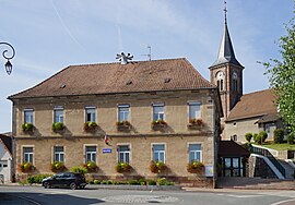 The town hall in Châlonvillars | |
 Coat of arms | |
Location of Châlonvillars  | |
 Châlonvillars | |
| Coordinates: 47°38′23″N 6°47′13″E / 47.6397°N 6.7869°ECoordinates: 47°38′23″N 6°47′13″E / 47.6397°N 6.7869°E | |
| Country | France |
| Region | Bourgogne-Franche-Comté |
| Department | Haute-Saône |
| Arrondissement | Lure |
| Canton | Héricourt-1 |
| Intercommunality | CC pays d'Héricourt |
| Area 1 | 7.60 km2 (2.93 sq mi) |
| Population (Jan. 2018)[1] | 1,243 |
| • Density | 160/km2 (420/sq mi) |
| Time zone | UTC+01:00 (CET) |
| • Summer (DST) | UTC+02:00 (CEST) |
| INSEE/Postal code | 70117 /70400 |
| Elevation | 363–493 m (1,191–1,617 ft) |
| 1 French Land Register data, which excludes lakes, ponds, glaciers > 1 km2 (0.386 sq mi or 247 acres) and river estuaries. | |


Châlonvillars is a commune in the Haute-Saône department in the region of Bourgogne-Franche-Comté in eastern France.
See also[]
References[]
- ^ "Populations légales 2018". The National Institute of Statistics and Economic Studies. 28 December 2020.
| Wikimedia Commons has media related to Châlonvillars. |
This Haute-Saône geographical article is a stub. You can help Wikipedia by . |
Categories:
- Communes of Haute-Saône
- Haute-Saône geography stubs