Genevrey
This article includes a list of references, related reading or external links, but its sources remain unclear because it lacks inline citations. (June 2018) |
Genevrey | |
|---|---|
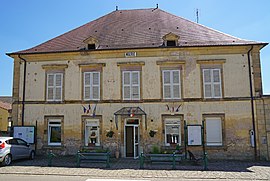 The town hall in Genevrey | |
show Location of Genevrey | |
 Genevrey | |
| Coordinates: 47°43′28″N 6°19′32″E / 47.7244°N 6.3256°ECoordinates: 47°43′28″N 6°19′32″E / 47.7244°N 6.3256°E | |
| Country | France |
| Region | Bourgogne-Franche-Comté |
| Department | Haute-Saône |
| Arrondissement | Lure |
| Canton | Lure-1 |
| Area 1 | 11.97 km2 (4.62 sq mi) |
| Population (Jan. 2018)[1] | 241 |
| • Density | 20/km2 (52/sq mi) |
| Time zone | UTC+01:00 (CET) |
| • Summer (DST) | UTC+02:00 (CEST) |
| INSEE/Postal code | 70263 /70240 |
| Elevation | 289–453 m (948–1,486 ft) |
| 1 French Land Register data, which excludes lakes, ponds, glaciers > 1 km2 (0.386 sq mi or 247 acres) and river estuaries. | |


Genevrey is a commune in the Haute-Saône department in the region of Bourgogne-Franche-Comté in eastern France.
See also[]
References[]
- ^ "Populations légales 2018". INSEE. 28 December 2020.
| Wikimedia Commons has media related to Genevrey. |
This Haute-Saône geographical article is a stub. You can help Wikipedia by . |
Categories:
- Communes of Haute-Saône
- Haute-Saône geography stubs