La Côte, Haute-Saône
From Wikipedia, the free encyclopedia
Commune in Bourgogne-Franche-Comté, France
La Côte | |
|---|---|
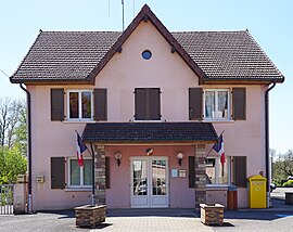 The town hall in La Côte | |
 Coat of arms | |
 La Côte  La Côte | |
Coordinates:  47°41′16″N 6°34′22″E / 47.6878°N 6.5728°E / 47.6878; 6.5728Coordinates: 47°41′16″N 6°34′22″E / 47.6878°N 6.5728°E / 47.6878; 6.5728 47°41′16″N 6°34′22″E / 47.6878°N 6.5728°E / 47.6878; 6.5728Coordinates: 47°41′16″N 6°34′22″E / 47.6878°N 6.5728°E / 47.6878; 6.5728 | |
| Country | France |
| Region | Bourgogne-Franche-Comté |
| Department | Haute-Saône |
| Arrondissement | Lure |
| Canton | Lure-2 |
| Area 1 | 6.93 km2 (2.68 sq mi) |
| Population (Jan. 2018)[1] | 521 |
| • Density | 75/km2 (190/sq mi) |
| Time zone | UTC+01:00 (CET) |
| • Summer (DST) | UTC+02:00 (CEST) |
| INSEE/Postal code | 70178 /70200 |
| Elevation | 307–362 m (1,007–1,188 ft) |
| 1 French Land Register data, which excludes lakes, ponds, glaciers > 1 km2 (0.386 sq mi or 247 acres) and river estuaries. | |

La Côte is a commune in the Haute-Saône department in the region of Bourgogne-Franche-Comté in eastern France.
See also[]
References[]
- ^ "Populations légales 2018". INSEE. 28 December 2020.
| Wikimedia Commons has media related to La Côte, Haute-Saône. |
| show Authority control | |
|---|---|
| General |
|
| National libraries | |
This Haute-Saône geographical article is a stub. You can help Wikipedia by . |
Retrieved from ""
Categories:
- Communes of Haute-Saône
- Haute-Saône geography stubs
Hidden categories:
- Articles with short description
- Short description is different from Wikidata
- Infobox mapframe without OSM relation ID on Wikidata
- Coordinates on Wikidata
- Pages using infobox settlement with image map1 but not image map
- Commons category link is on Wikidata
- Articles with VIAF identifiers
- Articles with BNF identifiers
- Articles with WorldCat-VIAF identifiers
- All stub articles
- Pages using the Kartographer extension