Châteaufort, Alpes-de-Haute-Provence
show This article may be expanded with text translated from the corresponding article in French. (December 2008) Click [show] for important translation instructions. |
Châteaufort | |
|---|---|
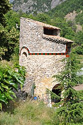 Dovecote of the chateau | |
 Coat of arms | |
show Location of Châteaufort | |
 Châteaufort | |
| Coordinates: 44°16′29″N 6°01′01″E / 44.2747°N 6.0169°ECoordinates: 44°16′29″N 6°01′01″E / 44.2747°N 6.0169°E | |
| Country | France |
| Region | Provence-Alpes-Côte d'Azur |
| Department | Alpes-de-Haute-Provence |
| Arrondissement | Forcalquier |
| Canton | Seyne |
| Government | |
| • Mayor (2020–2026) | Geneviève Demontis[1] |
| Area 1 | 13.73 km2 (5.30 sq mi) |
| Population (Jan. 2018)[2] | 28 |
| • Density | 2.0/km2 (5.3/sq mi) |
| Time zone | UTC+01:00 (CET) |
| • Summer (DST) | UTC+02:00 (CEST) |
| INSEE/Postal code | 04050 /04250 |
| Elevation | 541–1,280 m (1,775–4,199 ft) (avg. 610 m or 2,000 ft) |
| 1 French Land Register data, which excludes lakes, ponds, glaciers > 1 km2 (0.386 sq mi or 247 acres) and river estuaries. | |


Châteaufort (French pronunciation: [ʃɑtofɔʁ]) is a commune in the Alpes-de-Haute-Provence department in southeastern France.
Population[]
|
|
See also[]
References[]
- ^ "Répertoire national des élus: les maires". data.gouv.fr, Plateforme ouverte des données publiques françaises (in French). 2 December 2020.
- ^ "Populations légales 2018". INSEE. 28 December 2020.
| Wikimedia Commons has media related to Châteaufort, Alpes-de-Haute-Provence. |
This Alpes-de-Haute-Provence geographical article is a stub. You can help Wikipedia by . |
Categories:
- Communes of Alpes-de-Haute-Provence
- Alpes-de-Haute-Provence geography stubs