L'Escale
show This article may be expanded with text translated from the corresponding article in French. (December 2008) Click [show] for important translation instructions. |
L'Escale | |
|---|---|
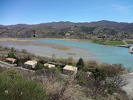 L'Escale Lake as viewed from Château-Arnoux-Saint-Auban. | |
 Coat of arms | |
show Location of L'Escale | |
 L'Escale | |
| Coordinates: 44°05′10″N 6°01′25″E / 44.0861°N 6.0236°ECoordinates: 44°05′10″N 6°01′25″E / 44.0861°N 6.0236°E | |
| Country | France |
| Region | Provence-Alpes-Côte d'Azur |
| Department | Alpes-de-Haute-Provence |
| Arrondissement | Digne-les-Bains |
| Canton | Château-Arnoux-Saint-Auban |
| Intercommunality | |
| Government | |
| • Mayor (2020–2026) | Claude Fiaert[1] |
| Area 1 | 20.36 km2 (7.86 sq mi) |
| Population (Jan. 2018)[2] | 1,380 |
| • Density | 68/km2 (180/sq mi) |
| Time zone | UTC+01:00 (CET) |
| • Summer (DST) | UTC+02:00 (CEST) |
| INSEE/Postal code | 04079 /04160 |
| Elevation | 408–1,081 m (1,339–3,547 ft) (avg. 475 m or 1,558 ft) |
| 1 French Land Register data, which excludes lakes, ponds, glaciers > 1 km2 (0.386 sq mi or 247 acres) and river estuaries. | |


L'Escale (French pronunciation: [lɛskal]; Occitan: L'Escala) is a commune in the Alpes-de-Haute-Provence department in southeastern France. It is located on the eastern bank of the Durance opposite Château-Arnoux-Saint-Auban.
Geography[]

The Bléone forms the commune's southern border, then flows into the Durance, which forms the commune's western border.
L'Escale Dam[]
Work began on the dam in 1959, which was completed in 1963.[3] With a height of 30ms it retains 15.70 hm³ of water.[3] It is 126 metres long with a road carriageway along which runs the Route Napoleon.[3] There is attached to the dam a power station whose three units produce a total of 170,000 KWs of electricity.[4]
Population[]
| Year | Pop. | ±% |
|---|---|---|
| 2006 | 1,235 | — |
| 2007 | 1,245 | +0.8% |
| 2008 | 1,255 | +0.8% |
| 2009 | 1,282 | +2.2% |
| 2010 | 1,311 | +2.3% |
| 2011 | 1,330 | +1.4% |
| 2012 | 1,349 | +1.4% |
| 2013 | 1,369 | +1.5% |
| 2014 | 1,384 | +1.1% |
| 2015 | 1,408 | +1.7% |
| 2016 | 1,399 | −0.6% |
See also[]
References[]
- ^ "Répertoire national des élus: les maires". data.gouv.fr, Plateforme ouverte des données publiques françaises (in French). 2 December 2020.
- ^ "Populations légales 2018". INSEE. 28 December 2020.
- ^ Jump up to: a b c Janberg, Nicolas Janberg. "L'Escale Dam (L'Escale/Château-Arnoux-Saint-Auban, 1963) | Structurae". Structurae. Nicolas Janberg. Retrieved 2 May 2017.
- ^ Plichon, J. N. (1968). Water for Peace: Volume 8 Planning and developing water programs. Washington: U.S. Government Printing Office. p. 394. Retrieved 2 May 2017.
| Wikimedia Commons has media related to L'Escale. |
This Alpes-de-Haute-Provence geographical article is a stub. You can help Wikipedia by . |
- Communes of Alpes-de-Haute-Provence
- Alpes-de-Haute-Provence geography stubs