La Palud-sur-Verdon
This article may be expanded with text translated from the corresponding article in French. (December 2008) Click [show] for important translation instructions.
|
La Palud-sur-Verdon | |
|---|---|
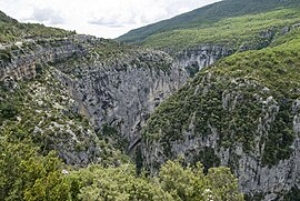 The Verdon river valley | |
 Coat of arms | |
Location of La Palud-sur-Verdon  | |
 La Palud-sur-Verdon | |
| Coordinates: 43°46′51″N 6°20′32″E / 43.7808°N 6.3422°ECoordinates: 43°46′51″N 6°20′32″E / 43.7808°N 6.3422°E | |
| Country | France |
| Region | Provence-Alpes-Côte d'Azur |
| Department | Alpes-de-Haute-Provence |
| Arrondissement | Castellane |
| Canton | Riez |
| Government | |
| • Mayor (2020–2026) | Michèle Bizot-Gastaldi |
| Area 1 | 81.26 km2 (31.37 sq mi) |
| Population (Jan. 2018)[1] | 350 |
| • Density | 4.3/km2 (11/sq mi) |
| Time zone | UTC+01:00 (CET) |
| • Summer (DST) | UTC+02:00 (CEST) |
| INSEE/Postal code | 04144 /04120 |
| Elevation | 471–1,920 m (1,545–6,299 ft) |
| 1 French Land Register data, which excludes lakes, ponds, glaciers > 1 km2 (0.386 sq mi or 247 acres) and river estuaries. | |


La Palud-sur-Verdon (French pronunciation: [la paly syʁ vɛʁdɔ̃]; Occitan: La Palú de Verdon) is a commune in the Alpes-de-Haute-Provence department in southeastern France.

Lavende field of the village.
Population[]
| Year | Pop. | ±% |
|---|---|---|
| 1765 | 575 | — |
| 1793 | 625 | +8.7% |
| 1800 | 629 | +0.6% |
| 1806 | 750 | +19.2% |
| 1821 | 862 | +14.9% |
| 1831 | 809 | −6.1% |
| 1836 | 853 | +5.4% |
| 1841 | 870 | +2.0% |
| 1846 | 784 | −9.9% |
| 1851 | 804 | +2.6% |
| 1856 | 780 | −3.0% |
| 1861 | 719 | −7.8% |
| 1866 | 756 | +5.1% |
| 1872 | 668 | −11.6% |
| 1876 | 646 | −3.3% |
| 1881 | 627 | −2.9% |
| 1886 | 578 | −7.8% |
| 1891 | 521 | −9.9% |
| 1896 | 467 | −10.4% |
| 1901 | 433 | −7.3% |
| 1906 | 464 | +7.2% |
| 1911 | 414 | −10.8% |
| 1921 | 350 | −15.5% |
| 1926 | 310 | −11.4% |
| 1931 | 277 | −10.6% |
| 1936 | 285 | +2.9% |
| 1946 | 215 | −24.6% |
| 1954 | 202 | −6.0% |
| 1962 | 154 | −23.8% |
| 1968 | 141 | −8.4% |
| 1975 | 152 | +7.8% |
| 1982 | 172 | +13.2% |
| 1990 | 243 | +41.3% |
| 1999 | 297 | +22.2% |
| 2008 | 303 | +2.0% |
See also[]
References[]
- ^ "Populations légales 2018". The National Institute of Statistics and Economic Studies. 28 December 2020.
| Wikimedia Commons has media related to La Palud-sur-Verdon. |
This Alpes-de-Haute-Provence geographical article is a stub. You can help Wikipedia by . |
Categories:
- Communes of Alpes-de-Haute-Provence
- Alpes-de-Haute-Provence geography stubs