Mallemoisson
show This article may be expanded with text translated from the corresponding article in French. (December 2008) Click [show] for important translation instructions. |
Mallemoisson | |
|---|---|
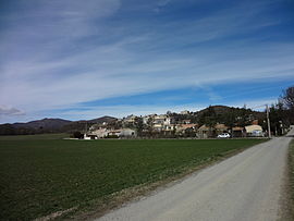 A general view of the village of Mallemoisson | |
 Coat of arms | |
show Location of Mallemoisson | |
 Mallemoisson | |
| Coordinates: 44°02′34″N 6°07′33″E / 44.0428°N 6.1258°ECoordinates: 44°02′34″N 6°07′33″E / 44.0428°N 6.1258°E | |
| Country | France |
| Region | Provence-Alpes-Côte d'Azur |
| Department | Alpes-de-Haute-Provence |
| Arrondissement | Digne-les-Bains |
| Canton | Digne-les-Bains-2 |
| Intercommunality | Provence-Alpes-Agglomération |
| Government | |
| • Mayor (2020–2026) | Jean-Paul Comte[1] |
| Area 1 | 6.04 km2 (2.33 sq mi) |
| Population (Jan. 2018)[2] | 1,029 |
| • Density | 170/km2 (440/sq mi) |
| Time zone | UTC+01:00 (CET) |
| • Summer (DST) | UTC+02:00 (CEST) |
| INSEE/Postal code | 04110 /04510 |
| Elevation | 476–663 m (1,562–2,175 ft) (avg. 505 m or 1,657 ft) |
| 1 French Land Register data, which excludes lakes, ponds, glaciers > 1 km2 (0.386 sq mi or 247 acres) and river estuaries. | |


Mallemoisson is a commune in the Alpes-de-Haute-Provence department in southeastern France.
Geography[]
The Bléone forms the commune's southern border.
Population[]
|
|
See also[]
References[]
- ^ "Répertoire national des élus: les maires". data.gouv.fr, Plateforme ouverte des données publiques françaises (in French). 2 December 2020.
- ^ "Populations légales 2018". INSEE. 28 December 2020.
| Wikimedia Commons has media related to Mallemoisson. |
| show Authority control |
|---|
This Alpes-de-Haute-Provence geographical article is a stub. You can help Wikipedia by . |
Categories:
- Communes of Alpes-de-Haute-Provence
- Alpes-de-Haute-Provence geography stubs