Saint-Paul-sur-Ubaye
This article may be expanded with text translated from the corresponding article in French. (December 2008) Click [show] for important translation instructions.
|
Saint-Paul-sur-Ubaye | |
|---|---|
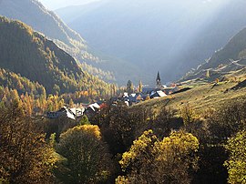 The hamlet of Grande Serenne, in Saint-Paul-sur-Ubaye | |
Location of Saint-Paul-sur-Ubaye  | |
 Saint-Paul-sur-Ubaye | |
| Coordinates: 44°30′57″N 6°45′08″E / 44.5158°N 6.7522°ECoordinates: 44°30′57″N 6°45′08″E / 44.5158°N 6.7522°E | |
| Country | France |
| Region | Provence-Alpes-Côte d'Azur |
| Department | Alpes-de-Haute-Provence |
| Arrondissement | Barcelonnette |
| Canton | Barcelonnette |
| Intercommunality | Vallée de l'Ubaye - Serre-Ponçon |
| Government | |
| • Mayor (2020–2026) | Bernard Isoard |
| Area 1 | 205.55 km2 (79.36 sq mi) |
| Population (Jan. 2018)[1] | 179 |
| • Density | 0.87/km2 (2.3/sq mi) |
| Time zone | UTC+01:00 (CET) |
| • Summer (DST) | UTC+02:00 (CEST) |
| INSEE/Postal code | 04193 /04530 |
| 1 French Land Register data, which excludes lakes, ponds, glaciers > 1 km2 (0.386 sq mi or 247 acres) and river estuaries. | |


Saint-Paul-sur-Ubaye (French pronunciation: [sɛ̃ pɔl syʁ ybaj], literally Saint-Paul on Ubaye; Vivaro-Alpine: Sant Pau d'Ubaia) is a commune in the Alpes-de-Haute-Provence department in southeastern France.
Population[]
|
|
See also[]
References[]
- ^ "Populations légales 2018". The National Institute of Statistics and Economic Studies. 28 December 2020.
| Wikimedia Commons has media related to Saint-Paul-sur-Ubaye. |
This Alpes-de-Haute-Provence geographical article is a stub. You can help Wikipedia by . |
Categories:
- Communes of Alpes-de-Haute-Provence
- Alpes-de-Haute-Provence geography stubs