Entrepierres
This article may be expanded with text translated from the corresponding article in French. (December 2008) Click [show] for important translation instructions.
|
Entrepierres | |
|---|---|
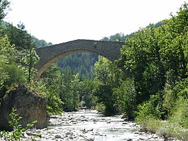 Bridge of Queen Jeanne | |
 Coat of arms | |
Location of Entrepierres  | |
 Entrepierres | |
| Coordinates: 44°13′08″N 6°00′08″E / 44.2189°N 6.0022°ECoordinates: 44°13′08″N 6°00′08″E / 44.2189°N 6.0022°E | |
| Country | France |
| Region | Provence-Alpes-Côte d'Azur |
| Department | Alpes-de-Haute-Provence |
| Arrondissement | Forcalquier |
| Canton | Sisteron |
| Intercommunality | Sisteronais Buëch |
| Government | |
| • Mayor (2020–2026) | Florence Cheilan |
| Area 1 | 47.79 km2 (18.45 sq mi) |
| Population (Jan. 2018)[1] | 373 |
| • Density | 7.8/km2 (20/sq mi) |
| Time zone | UTC+01:00 (CET) |
| • Summer (DST) | UTC+02:00 (CEST) |
| INSEE/Postal code | 04075 /04200 |
| Elevation | 455–1,444 m (1,493–4,738 ft) (avg. 600 m or 2,000 ft) |
| 1 French Land Register data, which excludes lakes, ponds, glaciers > 1 km2 (0.386 sq mi or 247 acres) and river estuaries. | |


Entrepierres (French pronunciation: [ɑ̃tʁəpjɛʁ]; Occitan: Entrepèiras) is a commune in the Alpes-de-Haute-Provence department in southeastern France.
Population[]
|
|
See also[]
- Communes of the Alpes-de-Haute-Provence department
- http://entrepierres.net/wiki/Accueil a wiki (mostly French) about Entrepierres
References[]
- ^ "Populations légales 2018". The National Institute of Statistics and Economic Studies. 28 December 2020.
| Wikimedia Commons has media related to Entrepierres. |
This Alpes-de-Haute-Provence geographical article is a stub. You can help Wikipedia by . |
Categories:
- Communes of Alpes-de-Haute-Provence
- Alpes-de-Haute-Provence geography stubs