Saint-Pons, Alpes-de-Haute-Provence
show This article may be expanded with text translated from the corresponding article in French. (December 2008) Click [show] for important translation instructions. |
Saint-Pons | |
|---|---|
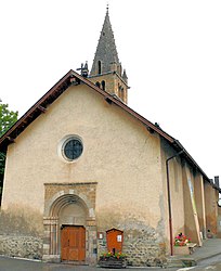 The church in Saint-Pons | |
show Location of Saint-Pons | |
 Saint-Pons | |
| Coordinates: 44°23′35″N 6°37′43″E / 44.3931°N 6.6286°ECoordinates: 44°23′35″N 6°37′43″E / 44.3931°N 6.6286°E | |
| Country | France |
| Region | Provence-Alpes-Côte d'Azur |
| Department | Alpes-de-Haute-Provence |
| Arrondissement | Barcelonnette |
| Canton | Barcelonnette |
| Government | |
| • Mayor (2020–2026) | Dominique Okroglic |
| Area 1 | 32.06 km2 (12.38 sq mi) |
| Population (Jan. 2018)[1] | 611 |
| • Density | 19/km2 (49/sq mi) |
| Time zone | UTC+01:00 (CET) |
| • Summer (DST) | UTC+02:00 (CEST) |
| INSEE/Postal code | 04195 /04400 |
| Elevation | 1,097–2,879 m (3,599–9,446 ft) (avg. 1,145 m or 3,757 ft) |
| 1 French Land Register data, which excludes lakes, ponds, glaciers > 1 km2 (0.386 sq mi or 247 acres) and river estuaries. | |


Saint-Pons (French pronunciation: [sɛ̃ pɔ̃s]; Occitan: Sant Ponç) is a commune in the Alpes-de-Haute-Provence department in southeastern France.
Population[]
|
|
See also[]
References[]
- ^ "Populations légales 2018". INSEE. 28 December 2020.
| Wikimedia Commons has media related to Saint-Pons, Alpes-de-Haute-Provence. |
| Authority control |
|
|---|
This Alpes-de-Haute-Provence geographical article is a stub. You can help Wikipedia by . |
Categories:
- Communes of Alpes-de-Haute-Provence
- Alpes-de-Haute-Provence geography stubs