Cheverny
Cheverny | |
|---|---|
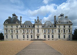 Château de Cheverny | |
 Coat of arms | |
show Location of Cheverny | |
 Cheverny | |
| Coordinates: 47°30′00″N 1°27′40″E / 47.5°N 1.4611°ECoordinates: 47°30′00″N 1°27′40″E / 47.5°N 1.4611°E | |
| Country | France |
| Region | Centre-Val de Loire |
| Department | Loir-et-Cher |
| Arrondissement | Blois |
| Canton | Vineuil |
| Intercommunality | CA Blois Agglopolys |
| Government | |
| • Mayor (2020–2026) | Lionella Gallard[1] |
| Area 1 | 33 km2 (13 sq mi) |
| Population (Jan. 2018)[2] | 929 |
| • Density | 28/km2 (73/sq mi) |
| Time zone | UTC+01:00 (CET) |
| • Summer (DST) | UTC+02:00 (CEST) |
| INSEE/Postal code | 41050 /41700 |
| Elevation | 78–116 m (256–381 ft) (avg. 85 m or 279 ft) |
| 1 French Land Register data, which excludes lakes, ponds, glaciers > 1 km2 (0.386 sq mi or 247 acres) and river estuaries. | |


Cheverny (/ʃəˈvɛərni, -ˈvɜːr-/, shə-VAIR-nee, shə-VUR-nee; French pronunciation: [ʃəvɛʁni]) is a commune in the French department of Loir-et-Cher, administrative region of Centre-Val de Loire.
It lies in the Loire Valley, about 10 km (6.2 mi) southeast of Blois.
Population[]
|
|
Sights[]
The commune is the site of the Château de Cheverny.
See also[]
- Communes of the Loir-et-Cher department
References[]
- ^ "Répertoire national des élus: les maires". data.gouv.fr, Plateforme ouverte des données publiques françaises (in French). 2 December 2020.
- ^ "Populations légales 2018". INSEE. 28 December 2020.
| Wikimedia Commons has media related to Cheverny. |
| show Communes of the Loir-et-Cher department |
|---|
| show Authority control |
|---|
This Loir-et-Cher geographical article is a stub. You can help Wikipedia by . |
Categories:
- Communes of Loir-et-Cher
- Loir-et-Cher geography stubs