Entrechaux
Entrechaux | |
|---|---|
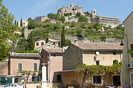 Buildings in Entrechaux | |
 Coat of arms | |
show Location of Entrechaux | |
 Entrechaux | |
| Coordinates: 44°13′07″N 5°08′19″E / 44.2186°N 5.1386°ECoordinates: 44°13′07″N 5°08′19″E / 44.2186°N 5.1386°E | |
| Country | France |
| Region | Provence-Alpes-Côte d'Azur |
| Department | Vaucluse |
| Arrondissement | Carpentras |
| Canton | Vaison-la-Romaine |
| Intercommunality | Vaison Ventoux |
| Government | |
| • Mayor (2020–2026) | Alexandre Roux |
| Area 1 | 14.91 km2 (5.76 sq mi) |
| Population (Jan. 2018)[1] | 1,128 |
| • Density | 76/km2 (200/sq mi) |
| Time zone | UTC+01:00 (CET) |
| • Summer (DST) | UTC+02:00 (CEST) |
| INSEE/Postal code | 84044 /84340 |
| Elevation | 210–463 m (689–1,519 ft) (avg. 284 m or 932 ft) |
| 1 French Land Register data, which excludes lakes, ponds, glaciers > 1 km2 (0.386 sq mi or 247 acres) and river estuaries. | |


Entrechaux (French pronunciation: [ɑ̃tʁəʃo]; Occitan: Entrechaums) is a commune in the Vaucluse department in the Provence-Alpes-Côte d'Azur region in southeastern France.
Sights and monuments[]
- Château d'Entrechaux, 10th-11th-century castle ruins, open to visitors in summer.
See also[]
- Communes of the Vaucluse department
References[]
- ^ "Populations légales 2018". INSEE. 28 December 2020.
| Wikimedia Commons has media related to Entrechaux. |
| Wikivoyage has a travel guide for Entrechaux. |
This Vaucluse geographical article is a stub. You can help Wikipedia by . |
Categories:
- Communes of Vaucluse
- Vaucluse geography stubs