Sault, Vaucluse
Sault | |
|---|---|
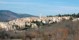 A general view of the village of Sault | |
 Coat of arms | |
show Location of Sault | |
 Sault | |
| Coordinates: 44°05′31″N 5°24′29″E / 44.0919°N 5.408°ECoordinates: 44°05′31″N 5°24′29″E / 44.0919°N 5.408°E | |
| Country | France |
| Region | Provence-Alpes-Côte d'Azur |
| Department | Vaucluse |
| Arrondissement | Carpentras |
| Canton | Pernes-les-Fontaines |
| Intercommunality | Ventoux Sud |
| Government | |
| • Mayor (2020–2026) | Claude Labro |
| Area 1 | 111.15 km2 (42.92 sq mi) |
| Population (Jan. 2018)[1] | 1,373 |
| • Density | 12/km2 (32/sq mi) |
| Time zone | UTC+01:00 (CET) |
| • Summer (DST) | UTC+02:00 (CEST) |
| INSEE/Postal code | 84123 /84390 |
| Elevation | 650–1,591 m (2,133–5,220 ft) (avg. 760 m or 2,490 ft) |
| 1 French Land Register data, which excludes lakes, ponds, glaciers > 1 km2 (0.386 sq mi or 247 acres) and river estuaries. | |


Sault is a commune in the Vaucluse department in the Provence-Alpes-Côte d'Azur region in southeastern France.
See also[]
- Communes of the Vaucluse department
References[]
- ^ "Populations légales 2018". INSEE. 28 December 2020.
| Wikimedia Commons has media related to Sault (Vaucluse). |
| show Authority control |
|---|
This Vaucluse geographical article is a stub. You can help Wikipedia by . |
Categories:
- Communes of Vaucluse
- Vaucluse geography stubs