Saint-Saturnin-lès-Apt
show This article may be expanded with text translated from the corresponding article in French. (July 2014) Click [show] for important translation instructions. |
Saint-Saturnin-lès-Apt | |
|---|---|
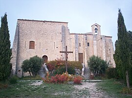 Chapel of the castle of Saint-Saturnin-lès-Apt | |
 Coat of arms | |
show Location of Saint-Saturnin-lès-Apt | |
 Saint-Saturnin-lès-Apt | |
| Coordinates: 43°56′42″N 5°23′04″E / 43.945°N 5.3844°ECoordinates: 43°56′42″N 5°23′04″E / 43.945°N 5.3844°E | |
| Country | France |
| Region | Provence-Alpes-Côte d'Azur |
| Department | Vaucluse |
| Arrondissement | Apt |
| Canton | Apt |
| Government | |
| • Mayor (2020–2026) | Christian Bellot[1] |
| Area 1 | 75.79 km2 (29.26 sq mi) |
| Population (Jan. 2018)[2] | 2,844 |
| • Density | 38/km2 (97/sq mi) |
| Time zone | UTC+01:00 (CET) |
| • Summer (DST) | UTC+02:00 (CEST) |
| INSEE/Postal code | 84118 /84490 |
| Elevation | 217–1,093 m (712–3,586 ft) (avg. 411 m or 1,348 ft) |
| 1 French Land Register data, which excludes lakes, ponds, glaciers > 1 km2 (0.386 sq mi or 247 acres) and river estuaries. | |


Saint-Saturnin-lès-Apt (French pronunciation: [sɛ̃ satyʁnɛ̃ lɛ.z‿apt], literally Saint-Saturnin near Apt; Provençal: Sant Savornin d’Ate) is a commune in the Vaucluse department in the Provence-Alpes-Côte d'Azur region in southeastern France.
Twin towns[]
 Castelfranco di Sopra, Italy
See also[]
- Communes of the Vaucluse department
- Luberon
Gallery[]
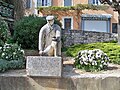
Statue of , in Saint-Saturnin-lès-Apt

References[]
- ^ "Répertoire national des élus: les maires". data.gouv.fr, Plateforme ouverte des données publiques françaises (in French). 2 December 2020. Retrieved 7 December 2020.
- ^ "Populations légales 2018". INSEE. 28 December 2020.
| Wikimedia Commons has media related to Saint-Saturnin-lès-Apt. |
| show Authority control |
|---|
This Vaucluse geographical article is a stub. You can help Wikipedia by . |
Categories:
- Communes of Vaucluse
- Vaucluse geography stubs