Goult
Goult | |
|---|---|
 Vineyard in autumn | |
 Coat of arms | |
show Location of Goult | |
 Goult | |
| Coordinates: 43°51′50″N 5°14′39″E / 43.8639°N 5.2442°ECoordinates: 43°51′50″N 5°14′39″E / 43.8639°N 5.2442°E | |
| Country | France |
| Region | Provence-Alpes-Côte d'Azur |
| Department | Vaucluse |
| Arrondissement | Apt |
| Canton | Apt |
| Government | |
| • Mayor (2020–2026) | Didier Perello[1] |
| Area 1 | 23.77 km2 (9.18 sq mi) |
| Population (Jan. 2018)[2] | 1,097 |
| • Density | 46/km2 (120/sq mi) |
| Time zone | UTC+01:00 (CET) |
| • Summer (DST) | UTC+02:00 (CEST) |
| INSEE/Postal code | 84051 /84220 |
| Elevation | 121–335 m (397–1,099 ft) |
| 1 French Land Register data, which excludes lakes, ponds, glaciers > 1 km2 (0.386 sq mi or 247 acres) and river estuaries. | |


Goult is a commune in the Vaucluse department in the Provence-Alpes-Côte d'Azur region in southeastern France. The village is perched on a hill with a solitary road to the peak. Near the end of the road is a 12th-century castle, the Chateau de Goult.
Geography[]
The commune lies in the parc naturel régional du Luberon.
The Calavon flows westward through the southern part of the commune.
Places and monuments[]
- Goult castle
- Saint Véran chapel
- Windmill
- Notre Dame des Lumières church

Saint Véran chapel
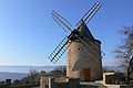
Old windmill

inside Notre Dame des Lumière church


See also[]

wine bottles product in Lumières, hamlet of Goult
- Luberon
- Côtes de Ventoux AOC
- Côtes du Luberon AOC
- Communes of the Vaucluse department
References[]
- ^ "Répertoire national des élus: les maires". data.gouv.fr, Plateforme ouverte des données publiques françaises (in French). 2 December 2020. Retrieved 7 December 2020.
- ^ "Populations légales 2018". INSEE. 28 December 2020.
External links[]
| Wikimedia Commons has media related to Goult. |
| show Authority control |
|---|
This Vaucluse geographical article is a stub. You can help Wikipedia by . |
Categories:
- Communes of Vaucluse
- Vaucluse geography stubs